It's 2pm EST on April 30. Spoke with Pat last night and this morning. He and his team are at Lukla, and it's a chaotic mess, as you can imagine. When I spoke with Global Rescue about the situation, my contact said it's like trying to empty a full football stadium 1 car at a time. Word is that Global Rescue will pick them up tomorrow. In the meantime, they've miraculously found them a hotel for the night and Pat and team have food and water, so they're safe there. The US Embassy is prioritizing evacuating the injured from that area, as they should. So for healthy people with resources, it's about being patient and not getting caught up in rushing the choppers & planes as they land, to get on & down to Kathmandu. The GR guy said it's actually better to be in Lukla right now than Kathmandu. They're even encouraging their clients who are trekking down from Base Camp to Lukla to take their time, if they have enough supplies, because it's going to get worse for awhile.
On another note, saw a few neighbors yesterday as I walked our dogs and I just want to say how amazing & supportive they've been -- kind words, offers of food, drive-by hugs even! We're so lucky to have such good peeps around us, in our neighborhood, online, on the phone, in prayers and good vibes :)
Many many thanks
Kathy

In April 2014, I attempted to climb Mt. Everest before an avalanche in the icefall claimed the lives of 18 Sherpa. A year later (May 2015), I returned to Mt. Everest only to witness a 7.8 earthquake while at camp 1. I am preparing to climb again in April 2018 but this blog is dedicated to my purposeful pursuits. Please be sure to check out the charities that I support and follow me on twitter (@pem725) or instagram (pem725).
Thursday, April 30, 2015
Check-in/OK message from SPOT PEM
PEM
Latitude:27.68732
Longitude:86.73244
GPS location Date/Time:04/30/2015 07:38:40 EDT
Message:Climbing in Mt. Everest right now. All is well; please check the map to see our progress.
Click the link below to see where I am located.
http://fms.ws/N9r5P/27.68732N/86.73244E
If the above link does not work, try this link:
http://maps.google.com/maps?f=q&hl=en&geocode=&q=27.68732,86.73244&ll=27.68732,86.73244&ie=UTF8&z=12&om=1
PEM
You have received this message because PEM has added you to their SPOT contact list.
Ready for Adventure
FindMeSPOT.com
Wednesday, April 29, 2015

Tuesday, April 28, 2015
Check-in/OK message from SPOT PEM
PEM
Latitude:27.89407
Longitude:86.81974
GPS location Date/Time:04/28/2015 23:59:33 EDT
Message:Climbing in Mt. Everest right now. All is well; please check the map to see our progress.
Click the link below to see where I am located.
http://fms.ws/N7-Vk/27.89407N/86.81974E
If the above link does not work, try this link:
http://maps.google.com/maps?f=q&hl=en&geocode=&q=27.89407,86.81974&ll=27.89407,86.81974&ie=UTF8&z=12&om=1
PEM
You have received this message because PEM has added you to their SPOT contact list.
Ready for Adventure
FindMeSPOT.com
Check-in/OK message from SPOT PEM
PEM
Latitude:28.00379
Longitude:86.85315
GPS location Date/Time:04/28/2015 19:14:35 EDT
Message:Climbing in Mt. Everest right now. All is well; please check the map to see our progress.
Click the link below to see where I am located.
http://fms.ws/N7lY6/28.00379N/86.85315E
If the above link does not work, try this link:
http://maps.google.com/maps?f=q&hl=en&geocode=&q=28.00379,86.85315&ll=28.00379,86.85315&ie=UTF8&z=12&om=1
PEM
You have received this message because PEM has added you to their SPOT contact list.
Ready for Adventure
FindMeSPOT.com
Wrapping Up
Oh happy day! It's 7:30am EST & I just spoke with Pat. He & the entire team are off Camp 1 & in Base Camp. Global Rescue saved the day -- they were the only ones with a heli up there & they got everyone down. They will be inundated with chocolate & flowers :)
The plan is for him, along with 3 of his climbing mates James, Sam & Alex, to get picked up tomorrow morning Nepal time, & flown into Kathmandu off the mountain. They will see a completely different city than the one they flew into. But they've seen that at Base Camp too. Pat said his tent was right up against the ridge where the avalanche hit. He found his stuff, and miraculously, all that happened was that his tent was flipped over. I'm glad he wasn't in it.
He told me what happened to him up at Camp 1. You'll have to get the story yourselves from him -- no doubt it will be here in his blog, told in the way only the Irish can manage :) By the way, I'm Irish & I didn't get that gift. I got the height (ha ha).
I'll update this blog when he gets into Kathmandu. And then I'm giving it back to him. Gladly!
Thank you all for your amazing emails, texts, calls, prayers, love & support. Some of you were afraid you were bothering me -- quite the opposite. You were holding me up. I am forever grateful for our amazing friends & family, & those who I don't even know who were there to help anyway. Truly amazing people you are.
A super grateful Kathy
p.s. Satellite phone reception isn't the best on the mountain, so I couldn't always hear Pat very well. When he was spelling the name of his sat phone service so I could add more minutes, he had to use the NATO alphabet (alpha, beta, charlie) -- but he didn't know which word to use for the letter U, so he said urethra. REALLY?! I laughed so hard.
Monday, April 27, 2015
YAYAYAYAYAYAYAYAYAYAYAY!!!!!!!!!!!!!!!!!!!
Yeah, you know it!!!!!!! Global Rescue got him down from Camp 1!!!!!! Pat is now at Base Camp waiting for the others to make it down, and looking for his stuff. He said Base Camp looked "flattened" & was unrecognizable. So now they have to figure out where their camp had been to find their gear. The next folks coming down are Alex and 2 Sherpa. The chopper was just landing with them when Pat called.
Global Rescue just called to make sure Pat made it on the transport down to EBC and the next step will be to get him to Lukla, where the airport he wrote about many moons ago, exists on the side of the mountain. That's the trip back to Kathmandu. That will be another adventure, but for now, I'm SO AMPED I CAN'T SLEEP!!!! AND I NEED TO! :)
Yay.
See what your prayers, positive thoughts & vibes have done :)
Still waiting for helis...
Hi all,
10pm EST and just spoke to Pat. They're all packed up & waiting for the helis to come. I've been in constant contact with Global Rescue -- they know they're waiting & the plan is to get them out today & at least down to Basecamp. But the choppers fly by Visual Flight Rules (new term I just learned) because they don't have the equipment to do otherwise. That means they can't fly if they can't see. And right now they can't see. We're waiting for a weather window to get them out.
Good news is the sun is shining at Camp 1 & Pat was happy to get warm! Weather comes up the mountain from the valley so even though they have clear skies, it's not clear below. Global Rescue is working hard to get them out of there. These guys are great & I appreciate everything they're doing. I'm staying in contact with Pat, hoping to chat in another hour to update him & vice versa.
Please keep sending your prayers, positive thoughts and good vibes to blow those clouds away & get these guys off the mountain! Many, many thanks to you all for your love & support, & for not letting me feel alone in this. I can't tell you how much this helps.
Much gratitude,
Kathy
Check-in/OK message from SPOT PEM
PEM
Latitude:27.98879
Longitude:86.87748
GPS location Date/Time:04/27/2015 19:48:05 EDT
Message:Climbing in Mt. Everest right now. All is well; please check the map to see our progress.
Click the link below to see where I am located.
http://fms.ws/N6SCd/27.98879N/86.87748E
If the above link does not work, try this link:
http://maps.google.com/maps?f=q&hl=en&geocode=&q=27.98879,86.87748&ll=27.98879,86.87748&ie=UTF8&z=12&om=1
PEM
You have received this message because PEM has added you to their SPOT contact list.
Ready for Adventure
FindMeSPOT.com
Still waiting for the helis
It's 8am on Monday EST, and I spoke with Pat throughout the night. Helicopters had been coming to Camp 1, and everyone but the Summit Climb team has left. It seems a few different decisions were being made -- whether to climb down, whether to wait it out a bit because of rumors of chaos at Base Camp, and whether they could actually get on the flights because of their insurance policies. In the case of rescue, climbing insurance companies will send flights to pick climbers up. So they thought they needed to get on flights sent by their insurance, but here, that's not the case. I spoke to Global Rescue (who have been fantastic) & they said these flights are all part of the government rescue, so anybody can get on them. So now Pat & his team know.
The flights have stopped for the day -- they don't have the instruments to fly at night. Global Rescue said they should resume tomorrow. Hopefully the weather will be good. I asked Pat who is on the mountain with them -- they are the last people up there as far as they know. These are all people with Summit Climb:
2 Romanian climbers (couldn't catch their names)
Meti from Finland (sorry about the spelling)
Pat & Jim from the U.S.
Sam & Alex, Pat's climbing buddies from the UK
Dan Mazur, Summit Climb's expedition leader
8 Sherpa (didn't get their names)
I spoke to Pat and Sam, and they sound good. Global Rescue knows they have provisions for a few days & knows they're waiting. Someone told me they had read a post that said that Dan Mazur said they were at Base Camp. They are not. They're at Camp 1 waiting to be picked up.
All your prayers, thoughts & positive vibes needed to clear the skies tomorrow morning so the helicopters can get in & they can get off the mountain!
Thank you everyone :)
Kathy
Sunday, April 26, 2015
Quick update
Hi all,
For those of you not following Twitter or the Everest blogs out there, just wanted to let you know that Dan Mazur has been tweeting a few times since the earthquake & keeping us all updated on their situation at Camp 1. Looks like some folks scouted out the Ice Fall route. His tweet says the good news is that the route is still there; the bad news is that it is not in good shape; and the "very bad" news is that the Ice Fall sherpas' Base Camp is gone. I can't tell if that means they are too. But other bloggers at Base Camp are saying that sherpa are working to get supplies to Camps 1 & 2. It's not clear if the Summit Climb team and/or others are going to try to climb down to Base Camp, or wait to be evacuated by helicopter. Apparently some teams have been evacuated, and it looks like it's been from both Camps 1 & 2. Pat's most recent SPOT check was a few minutes ago, about 10:40pm EST & from the looks of it, they are still at Camp 1.
Sam Chappatte's mom, (he's climbing with Pat) emailed to let me know that there have been discussions with the Indian military to get them out of Camp 1 via helicopter on Monday. I'll keep you posted as I hear.
The good news is Pat and team are okay -- as long as the SPOT messages are coming in, they're hanging in there.
I'll keep updating as I learn more.
Thank you for all your prayers, thoughts & positive vibes -- they're keeping the climbers going! And us here at home too.
Kathy
Check-in/OK message from SPOT PEM
PEM
Latitude:27.98753
Longitude:86.87718
GPS location Date/Time:04/26/2015 22:29:07 EDT
Message:Climbing in Mt. Everest right now. All is well; please check the map to see our progress.
Click the link below to see where I am located.
http://fms.ws/N5L7z/27.98753N/86.87718E
If the above link does not work, try this link:
http://maps.google.com/maps?f=q&hl=en&geocode=&q=27.98753,86.87718&ll=27.98753,86.87718&ie=UTF8&z=12&om=1
PEM
You have received this message because PEM has added you to their SPOT contact list.
Ready for Adventure
FindMeSPOT.com
Check-in/OK message from SPOT PEM
PEM
Latitude:27.98748
Longitude:86.87720
GPS location Date/Time:04/26/2015 08:17:05 EDT
Message:Climbing in Mt. Everest right now. All is well; please check the map to see our progress.
Click the link below to see where I am located.
http://fms.ws/N4XQ4/27.98748N/86.87720E
If the above link does not work, try this link:
http://maps.google.com/maps?f=q&hl=en&geocode=&q=27.98748,86.87720&ll=27.98748,86.87720&ie=UTF8&z=12&om=1
PEM
You have received this message because PEM has added you to their SPOT contact list.
Ready for Adventure
FindMeSPOT.com
Heard from Pat!
Good news -- Pat called on his satellite phone at midnight EST, 9:45am on Sunday for him. He and his team are doing well, given what they've just been through. An avalanche went through Camp 1 but everyone is okay -- the Sherpa rounded up tents for those whose were destroyed, and there are quite a few people up there together, which makes it better for everyone. They have food and provisions, so they're okay. Pat is sharing his sat phone with others so they can call their families.
Everyone up there is in the dark regarding what happened -- all they know was that they were hit with an earthquake. I told them about Kathmandu and the strength & center of the earthquake. It sounded like they were hit hard by the quake up at Camp 1, but nobody was hurt and the big message is that everyone is okay.
It made me happy to hear Pat say "Man have I got some stories to tell you and Patrick when I get home!" I can't wait.
Saturday, April 25, 2015
Check-in/OK message from SPOT PEM
PEM
Latitude:27.98749
Longitude:86.87720
GPS location Date/Time:04/25/2015 19:46:22 EDT
Message:Climbing in Mt. Everest right now. All is well; please check the map to see our progress.
Click the link below to see where I am located.
http://fms.ws/N43Ad/27.98749N/86.87720E
If the above link does not work, try this link:
http://maps.google.com/maps?f=q&hl=en&geocode=&q=27.98749,86.87720&ll=27.98749,86.87720&ie=UTF8&z=12&om=1
PEM
You have received this message because PEM has added you to their SPOT contact list.
Ready for Adventure
FindMeSPOT.com
By now you know that a massive earthquake hit Nepal around noon on April 25th. Mt. Everest was hit hard, and according to the news, parts of Base Camp and the Khumbu Ice Fall are destroyed. This is Kathy, Pat's wife, checking in. I am writing this for Pat, to share all the news I know at this point about Pat. He called me yesterday to let me know he was leaving Base Camp with a team (I'm assuming Sam & Alex are with him) for what he thought might be a 10-day trek up to Camps 1, 2 and 3, after which they'd come back down to Base Camp and then prepare to summit. They must have left before the earthquake, which is good news because they got through the Ice Fall before the earthquake hit. Tweets from Camp 1 indicate that the climbers definitely felt the earthquake up there, and heard what was called ear shattering booms as an avalanche and rocks were released above and into Base Camp. They may not have a camp to return to. It also sounds like Dan Mazur, their expedition leader from Summit Climb is with them. This is good news because Pat has always talked about Dan as a level-headed guy who remains calm throughout the storm. He was that person last year during the infamous avalanche, and I'm sure he's that person now.
Sam's mother and I have been in contact and she let me know that Sam tweeted that they were shaken but safe. She also said the directors were meeting at Camp 1 to determine if they were going to go up to Camp 2 or try going back down. Twitter feeds say the same (follow #Everest if you're following climbers on the mountain). I'm posting this info on Facebook, but wanted to share it here since most of you following him are not connected with me on FB.
I'm counting on the fact that he was planning on being gone for 10 days, that he has enough food and equipment, and with his team, they'll all be safe. Word on the mountain is that the Indian Army is sending in helicopters to Base Camp, and medics are there trying to help the injured. No word on how those above the Ice Fall are going to get down. When I find out, I'll post here.
Please send prayers, good vibes, positive thoughts--whatever you have -- to Nepal and Mt. Everest. They need to know they are not alone and we are pushing and pulling for them.
With gratitude for your tremendous support of Pat's climb,
Kathy
Check-in/OK message from SPOT PEM
PEM
Latitude:27.98760
Longitude:86.87721
GPS location Date/Time:04/25/2015 06:40:37 EDT
Message:Climbing in Mt. Everest right now. All is well; please check the map to see our progress.
Click the link below to see where I am located.
http://fms.ws/N3C97/27.98760N/86.87721E
If the above link does not work, try this link:
http://maps.google.com/maps?f=q&hl=en&geocode=&q=27.98760,86.87721&ll=27.98760,86.87721&ie=UTF8&z=12&om=1
PEM
You have received this message because PEM has added you to their SPOT contact list.
Ready for Adventure
FindMeSPOT.com
Check-in/OK message from SPOT PEM
PEM
Latitude:27.98756
Longitude:86.87718
GPS location Date/Time:04/25/2015 05:38:35 EDT
Message:Climbing in Mt. Everest right now. All is well; please check the map to see our progress.
Click the link below to see where I am located.
http://fms.ws/N39Gk/27.98756N/86.87718E
If the above link does not work, try this link:
http://maps.google.com/maps?f=q&hl=en&geocode=&q=27.98756,86.87718&ll=27.98756,86.87718&ie=UTF8&z=12&om=1
PEM
You have received this message because PEM has added you to their SPOT contact list.
Ready for Adventure
FindMeSPOT.com
Check-in/OK message from SPOT PEM
PEM
Latitude:27.98852
Longitude:86.87797
GPS location Date/Time:04/25/2015 03:17:35 EDT
Message:Climbing in Mt. Everest right now. All is well; please check the map to see our progress.
Click the link below to see where I am located.
http://fms.ws/N33Oe/27.98852N/86.87797E
If the above link does not work, try this link:
http://maps.google.com/maps?f=q&hl=en&geocode=&q=27.98852,86.87797&ll=27.98852,86.87797&ie=UTF8&z=12&om=1
PEM
You have received this message because PEM has added you to their SPOT contact list.
Ready for Adventure
FindMeSPOT.com
Check-in/OK message from SPOT PEM
PEM
Latitude:27.98854
Longitude:86.87801
GPS location Date/Time:04/25/2015 02:36:26 EDT
Message:Climbing in Mt. Everest right now. All is well; please check the map to see our progress.
Click the link below to see where I am located.
http://fms.ws/N31st/27.98854N/86.87801E
If the above link does not work, try this link:
http://maps.google.com/maps?f=q&hl=en&geocode=&q=27.98854,86.87801&ll=27.98854,86.87801&ie=UTF8&z=12&om=1
PEM
You have received this message because PEM has added you to their SPOT contact list.
Ready for Adventure
FindMeSPOT.com
Check-in/OK message from SPOT PEM
PEM
Latitude:27.98851
Longitude:86.87791
GPS location Date/Time:04/25/2015 01:43:36 EDT
Message:Climbing in Mt. Everest right now. All is well; please check the map to see our progress.
Click the link below to see where I am located.
http://fms.ws/N2_w2/27.98851N/86.87791E
If the above link does not work, try this link:
http://maps.google.com/maps?f=q&hl=en&geocode=&q=27.98851,86.87791&ll=27.98851,86.87791&ie=UTF8&z=12&om=1
PEM
You have received this message because PEM has added you to their SPOT contact list.
Ready for Adventure
FindMeSPOT.com
Thursday, April 23, 2015
Check-in/OK message from SPOT PEM
PEM
Latitude:28.00846
Longitude:86.85306
GPS location Date/Time:04/23/2015 21:00:14 EDT
Message:Climbing in Mt. Everest right now. All is well; please check the map to see our progress.
Click the link below to see where I am located.
http://fms.ws/N1SqO/28.00846N/86.85306E
If the above link does not work, try this link:
http://maps.google.com/maps?f=q&hl=en&geocode=&q=28.00846,86.85306&ll=28.00846,86.85306&ie=UTF8&z=12&om=1
PEM
You have received this message because PEM has added you to their SPOT contact list.
Ready for Adventure
FindMeSPOT.com
Check-in/OK message from SPOT PEM
PEM
Latitude:28.00387
Longitude:86.85310
GPS location Date/Time:04/23/2015 05:59:38 EDT
Message:Climbing in Mt. Everest right now. All is well; please check the map to see our progress.
Click the link below to see where I am located.
http://fms.ws/N0RWx/28.00387N/86.85310E
If the above link does not work, try this link:
http://maps.google.com/maps?f=q&hl=en&geocode=&q=28.00387,86.85310&ll=28.00387,86.85310&ie=UTF8&z=12&om=1
PEM
You have received this message because PEM has added you to their SPOT contact list.
Ready for Adventure
FindMeSPOT.com
Wednesday, April 22, 2015
Check-in/OK message from SPOT PEM
PEM
Latitude:28.00041
Longitude:86.85039
GPS location Date/Time:04/22/2015 10:05:13 EDT
Message:Climbing in Mt. Everest right now. All is well; please check the map to see our progress.
Click the link below to see where I am located.
http://fms.ws/M_H64/28.00041N/86.85039E
If the above link does not work, try this link:
http://maps.google.com/maps?f=q&hl=en&geocode=&q=28.00041,86.85039&ll=28.00041,86.85039&ie=UTF8&z=12&om=1
PEM
You have received this message because PEM has added you to their SPOT contact list.
Ready for Adventure
FindMeSPOT.com
Tuesday, April 21, 2015
Check-in/OK message from SPOT PEM
PEM
Latitude:28.00377
Longitude:86.85315
GPS location Date/Time:04/21/2015 23:15:30 EDT
Message:Climbing in Mt. Everest right now. All is well; please check the map to see our progress.
Click the link below to see where I am located.
http://fms.ws/M-oe2/28.00377N/86.85315E
If the above link does not work, try this link:
http://maps.google.com/maps?f=q&hl=en&geocode=&q=28.00377,86.85315&ll=28.00377,86.85315&ie=UTF8&z=12&om=1
PEM
You have received this message because PEM has added you to their SPOT contact list.
Ready for Adventure
FindMeSPOT.com
Check-in/OK message from SPOT PEM
PEM
Latitude:28.00390
Longitude:86.85351
GPS location Date/Time:04/21/2015 02:50:06 EDT
Message:Climbing in Mt. Everest right now. All is well; please check the map to see our progress.
Click the link below to see where I am located.
http://fms.ws/Mzbh3/28.00390N/86.85351E
If the above link does not work, try this link:
http://maps.google.com/maps?f=q&hl=en&geocode=&q=28.00390,86.85351&ll=28.00390,86.85351&ie=UTF8&z=12&om=1
PEM
You have received this message because PEM has added you to their SPOT contact list.
Ready for Adventure
FindMeSPOT.com
Monday, April 20, 2015
Check-in/OK message from SPOT PEM
PEM
Latitude:27.94843
Longitude:86.80995
GPS location Date/Time:04/20/2015 19:50:36 EDT
Message:Climbing in Mt. Everest right now. All is well; please check the map to see our progress.
Click the link below to see where I am located.
http://fms.ws/MzJuC/27.94843N/86.80995E
If the above link does not work, try this link:
http://maps.google.com/maps?f=q&hl=en&geocode=&q=27.94843,86.80995&ll=27.94843,86.80995&ie=UTF8&z=12&om=1
PEM
You have received this message because PEM has added you to their SPOT contact list.
Ready for Adventure
FindMeSPOT.com
Sunday, April 19, 2015
Post Namche rest day: What to do, what to do
It is 3:45am in Namche. The reason I'm awake right now is somewhat complicated. First, after my leisurely day of eating and drinking, I decided to take a nap from 3-6:45pm. Getting up from that nap was brutal. I went down to my tea house dining room and had some chicken curry with white rice. It was great but I was falling asleep while eating. That sleepiness drove me to bed again where I slept from 9pm until about 3am. Not a bad night's rest if you count a 2 hour meal time as a useful break to a 9.5 hour night. I don't. I like my sleep contiguous - that is, without interruption. So I lay hear typing my blog update...
The second reason why I am awake is due to my new friend - an invisible friend to me but definitely not an imaginative friend. My new friend is a rat or mouse who seems to take special delight in scratching the wall by my head. This animal has been going crazy with it's scratching and no matter how many times I knock on the wall, it just keeps going on with it's nightly duty.
So, between getting enough sleep and being awoken by a critter in my wall, I lay here fully rested and alert. I'm ready to move up after yesterday's 3 large meals and 5 liters of tea. Where do I go?
Option 1: Dingboche (5 hours)
I head up to Dingboche to possibly meet up with Sam and Alex. Sam sent me a FB message saying that they would be in Dingboche through today but I am not sure if they will be there when I arrive. Dingboche is an OK stop but not one of my favorites. I would go there if those two were going to stay the night but that little village doesn't offer me much beyond a place to crash. A night of catching up with Sam and Alex would be a welcomed change. Plus, I really look forward to seeing them again.
Option 2: Lobuche (8 hours)
An alternative to Dingboche is to trek a little longer and get to a higher, more remote village where I can really get back to altitude. You see, this part of the trek is hardly a stress on my body. I say that not in a boastful manner but as a real assessment of the situation. Yesterday, I woke up with a morning spO2 reading of 98 in Namche. I think and know that my hypoxic training is paying off. These lower levels just allow me to recover quickly and to stay healthy. So far, so good. Lobuche would provide a nice stressor and get me closer to basecamp. Both of those benefits seem appealing.
Option 3: EBC (12 hours)
This option is not prudent for several reasons. First, Dan sent us - sent Sam actually - a note to not rush. His note said "take your time; no climbing for another 10 days or so." Still, I would like to escape the Khumbu Valley unscathed and the best way to achieve that goal is to get out of it. With a huge push today, I could get to basecamp in about 12 hours with stops for food and gear changes.
I am not sure which option makes the most sense right now as I lay here in my comfortable sleeping bag with WiFi. The best option may emerge as I approach each destination. My general feeling is that I will go for either of the latter two UNLESS Sam and Alex are still in Dingboche. Typing out my options helped me reason through them. Thanks for allowing me the think aloud session.
OK, it is 4:30am. I have to pack up and get on the road no later than 5:30am if I want a serious shot at EBC. Hopefully WiFi works in those destinations I wrote about above.
All is well. Hope this update finds all of you as comfortable as I am in Namche. More updates later when I reach my destination.

Saturday, April 18, 2015

Now resting and relaxing at the Namche cyber cafe
Life is good here in the Khumbu Valley. I made it up from Lukla to Namche in 6 hours yesterday. Felt great and took my time. It sure helps to be acclimatized to 22,000 feet when you trek at 10-14,000 feet. Life is easy.
Today, I plan to rest here and let my body fully recover from a 6 hour day. I will eat well, sleep a ton, and drink 5 to 6 liters before I crash tonight. So far today, I had an omelette, home fries, toast, coffee, and bacon. Sounds like I'm really roughing it, eh?
Tomorrow, I plan to meet Sam and Alex in Dingboche. They had a puja in Pangboche yesterday and are hanging out there today and then head out to Dingboche in the morning. Will be great to see them - first time since last May. We should have a few rousing rounds of hearts tomorrow night. I can't wait.
Met a ton of really interesting people. All of them trekkers and each with great stories. I love this part of climbing. Meeting new people, hearing their stories, and telling a few of my own. I really feel fortunate to experience this adventure in great health.
Hello followers of Pat's climbing adventures! Thanks for following & supporting him. He's trained hard for this and if anybody has it in themselves to overcome the upcoming challenges & stand at the top of the world, its Pat. I know because he's my best friend & I see it every day, his passion, focus, & determination. Yes, sometimes it's rough to miss out on a Friday night movie because he has 9 hours of workouts on Summit Saturdays, and it can get really hard when you hear there's been an avalanche & conflicting reports about loss of life. But I wouldn't want him to be any other way. I get the passion & dedication to a physical & mental challenge. It can be selfish sometimes, but it also gives life to those around you who are ignited by your fire.
So I wasn't supposed to be writing all that but thats what came out! All I was supposed to do was tell you he's okay & making his way to Basecamp--on little sleep & less food. Once he gets to a comfortable altitude, just slightly lower than the one at which our plane flew today to Chicago (!) , he'll get a chance to catch up on sleep & get ready for the big push. Please send good vibes his way -- your good wishes will push him up the hill ☺
Thank you for following & supporting my adventurous, awesome hubby! From sea-level ,
Kat
Check-in/OK message from SPOT PEM
PEM
Latitude:27.80439
Longitude:86.71041
GPS location Date/Time:04/18/2015 21:16:40 EDT
Message:Climbing in Mt. Everest right now. All is well; please check the map to see our progress.
Click the link below to see where I am located.
http://fms.ws/MwseQ/27.80439N/86.71041E
If the above link does not work, try this link:
http://maps.google.com/maps?f=q&hl=en&geocode=&q=27.80439,86.71041&ll=27.80439,86.71041&ie=UTF8&z=12&om=1
PEM
You have received this message because PEM has added you to their SPOT contact list.
Ready for Adventure
FindMeSPOT.com
Friday, April 17, 2015
Chilling out at the Shakti hotel.... Check-in/OK message from SPOT PEM
Yep, here I am. It is 3:06 local time and I am posting updates to my blog. I landed as scheduled last night without drama and crashed at 8am. After sorting my gear last night and repacking for my flight today, I managed to hit the rack at 8pm local time only to awake at 1:30am with no chance to fall back asleep. Additionally, my clocks on my cell phone and watch were completely messed up. So, I sit here waiting and ready to start my trek up the Khumbu valley. If all goes well, I will be in Namche by dinner time and ready for a long night sleep. All is well. Met some nice folks on the flight. Enjoyed the travel day immensely. See you soon....
PEM
Latitude:27.71671
Longitude:85.31268
GPS location Date/Time:04/17/2015 16:42:58 EDT
Message:Climbing in Mt. Everest right now. All is well; please check the map to see our progress.
Click the link below to see where I am located.
http://fms.ws/Mv7vr/27.71671N/85.31268E
If the above link does not work, try this link:
http://maps.google.com/maps?f=q&hl=en&geocode=&q=27.71671,85.31268&ll=27.71671,85.31268&ie=UTF8&z=12&om=1
PEM
You have received this message because PEM has added you to their SPOT contact list.
Ready for Adventure
FindMeSPOT.com
Thursday, April 16, 2015
Already some difficulty with the new icefall route
Alan Arnette was gracious enough to post an update about the icefall route. Apparently, the icefall doctors experienced some problems with the ladders. Please consult his blog for the complete update. Be sure to look at the enlarged picture so you can see the trouble spot.
The internet must be working pretty well at basecamp. I read many updates from various climbers. Thanks to Alan for keeping us all abreast of the situation. Glad I stayed home and acclimatized in my own bed. Just another reason why I thank the good folks at Hypoxico and, in particular, Brian Oestrike for helping me with this whole process.
Expect updates as the roll in.....
Thanks for following.
A few thoughts as I prepare to climb
Greetings. I am sitting here thinking about the past few years that I devoted to this one singular event. Last year, my climb got derailed by factors beyond my control. This year, I felt as if I did everything within my control to maximize a safe, successful climb. I trained hard, rested, ate well, and stayed healthy. Moreover, I climbed a ton and sorted out my gear with every climb. I sit here today thinking about the last few years and reminiscing about what I did and why I believe I am ready for the next two months. Below are a few thoughts on that topic...
1. Control the controllable. Climbing and preparing the climb both take a singular focus. Many times, however, that focus drifts to the "what ifs," "should haves," and "could haves." Given the nature of these big mountains and the costs associated with climbing them, I decided that I would put all my efforts into controlling what I could control and leave chance alone.
2. Prepare for the unexpected. As Louis Pasteur once said "chance favors the prepared mind" and I felt like I prepared by controlling every aspect of my preparation that I could control. Preparation for climbing takes discipline and dedication. In retrospect, I am very happy with what I was able to accomplish during those years. I controlled what I could control and feel as if chance will favor me and my preparation.
3. Accept adversity. I mentioned in a previous post how that "one thing" can often set the tone for an entire day, climb, or relationship. Adverse conditions - whether internally or externally generated - often create those moments that change the tenor or mood. Last year, that one thing consisted of many events that added up to a nightmare for many of us. Fortunately, the "many" were able to live past the event but my thoughts remain with those who were not so fortunate. I decided that this year I would allow myself to accept adversity and learn from it. More often than not, those adverse events or conditions simply show up unannounced and unprovoked. How we deal with them shows our true character. I must admit, I had many instances of not holding it together as the climb deteriorated last year. This year, I return with no ill-will nor with any agenda other than to climb. I accepted my fate from last year and moved on. Here is to adversity!
4. Stay focused. There were a few times over the past two years that I wanted to rest. I was done. The training slowly ate away at my resolve. Those times were quickly subdued by climbing, running, sleeping, drinking, eating, swimming, sailing, socializing or some other activity where I could reflect on my primary objective. It would be overstating the case if I said I were constantly focused. Training has a way of eroding that focus over time. Now that I am done training and completely rested, I have nothing to distract me. I stayed late at home to finish many of my projects, to guide my students through the end of their semester, and to spend more time with my family. Now that I did all that, I can leave with a clear conscience that I did all I could do for those other things and now I get to focus solely on this climb.
5. Ready for a change. I spent the last few years really focused on climbing Mt. Everest. Now that I am close to reaching that goal - weather and conditions permitting - I feel ready to shift gears for a little bit and embrace a little change. Perhaps I might train for another climb, another endurance event, or just go sailing. Regardless, I need a new objective. Everest has been a great goal and I am really excited about the prospects of reaching that goal. What is next? Who knows. First things first....climb that big hill.
Thanks for following along. I'll have more posts shortly. The climb starts soon. Stay tuned....
Wednesday, April 15, 2015
Getting ready to climb with Olivia
Hi all. My final preparations began in earnest today as I finalized my packing and got ready to head out. Things came together nicely without any problems. The one thing I am really psyched about is my new Olivia pennants. Dorothy and Steven sent me a really nice North Sails pennant that works really well on the water but it absorbs water on the mountain and then freezes. A frozen pennant weighs about 2 lbs (almost 1 kg). I intend to bring that original pennant since it accompanied me on my previous climb in Nepal and on my Aconcagua trip. The summit push up Everest mandates that I slim down as much as possible - not me personally but I ought to reduce the weight as much as humanly possible. So, with the help of Karen Friedman, I am now the proud owner of two new rip-stop pennants with the Olivia logo. Thanks to Karen for helping me at the last second. She did a wonderful job. I also want to thank the Olivia Constants Foundation for letting me climb with Olivia.

It is truly an honor and one I take seriously. For those of you who are new to my blog, I ask you to consider giving to this great cause. The link to the right takes you to their website.
Below is the before and after pictures of the pennants (top before, bottom after):

Thanks everyone for the continued support. I can't wait to head off to Nepal.
It is truly an honor and one I take seriously. For those of you who are new to my blog, I ask you to consider giving to this great cause. The link to the right takes you to their website.
Below is the before and after pictures of the pennants (top before, bottom after):
Thanks everyone for the continued support. I can't wait to head off to Nepal.
Tuesday, April 14, 2015
Hey, look what came in the (e)mail today....
 |
| My 2015 Everest Permit |
Documenting the climb - one section at a time (Camp 3 to the Everest Summit)
Greetings. I trust this post finds you all well. All is well with me as I prepare to leave. Today, I post my final leg of the climb and then wrap up the climb with an awesome graphic and two videos worth watching. As I read through my blog after the last post, I came to the realization that some people may think that I am actually climbing right now. Rest assured, I am sitting in my kitchen typing this post. Things are going pretty well in Nepal right now but I sure am happy to be in Fairfax, VA, eating my own food, and staying healthy. I feel great. I am eating a ton and gaining weight to the point where I might actually leave at my goal of 180 lbs (81.6 kg). So far, so good. OK, the last leg of the climb...
Camp 3 (23,500 feet or 7160 m) to the Summit (29,029 feet or 8,848 m)
The Yellow Band (top at 25,000 feet or 7620 m: 1-3 hours from Camp 3). The push up from Camp 3 starts as a rapid ascent to the Yellow Band - a strip of sedimentary sandstone rock that appears yellow from all angles. Here (below) is a good picture of the Yellow Band:
More on the Yellow Band.... For those of you who are interested in the geology of Everest, I highly recommend you watch this brief video below.
In the video, Dave Lageson - a geology professor at Montana State University - describes the composition of the Yellow Band. He along with team leader Conrad Anker, climbed Mt. Everest in 2012 with a team from the Everest Education Expedition. Watch the video and check out Dave's other educational materials if you find this topic interesting. OK, back to the route.
Dry Tooling. You can clearly see that the Yellow Band is a stark departure from the glacier travel that we covered over the past three legs. Finally, some rock! Of course, that departure from the normal glacier creates some problems for climbers who are not accustomed to "dry tooling" on rock. The Yellow Band is brief (100m of rope at the most to traverse it) and does not require too much energy to overcome these days due to fixed ropes and well packed down routes where snow may exist. Also, there is little vertical gained during the crossing of the Yellow Band. We simply traverse the route to aim toward the next objective.
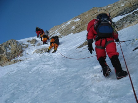
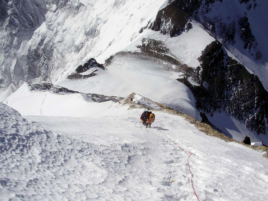
The Geneva Spur (25,500 feet or 7,772 m - 1-2 hours from the Yellow Band). Once past the Yellow Band, we head up past the point where the Lohtse climbers bear to the right while we Everest climbers climb on toward the Geneva Spur. Here is an excellent image of what the spur looks like (see below):
The Geneva Spur - like the Yellow Band - consists of a mixture of rock and ice. During years when the snowfall is particularly heavy, the Geneva spur may have loose snow that inhibits climbers from climbing quickly past this section. At this point, climbers usually take between 2 and 5 hours to reach the Geneva Spur from Camp 3 - the faster ones do it in 2 hours while others who take their time or struggle with the thin air may take as many as 5 hours.
South Col or Camp 4 (26,400 feet or 8000 m: about 1 hour from the Geneva Spur). Passing the Geneva Spur and pressing onward, climbers approach the South Col in about an hour. The South Col is where climbers enter "The Death Zone" or the altitude where climbers' bodies cannot sustain life. At the Col - a flat portion of the climb that forms the saddle between Everest and Lohtse - some expeditions setup a camp to allow tired climbers to rest and recover from the 3-6 hours of high altitude climbing. The South Col is a windy place that offers very little shelter from Everest's brutal conditions. Below is an excellent photo from the South Col. You can see that most climbers use oxygen at this point. Also, you'll notice a huge cache of oxygen bottles - most full and ready for climbers who pass by the Col and head up towards the summit.
Life at the South Col can be quite taxing. Climbers struggle to recover and there is little rest that awaits us. Breathing oxygen through a mask makes for an awkward nap - even for the most fatigued climbers. A brief break of a few hours, however, affords climbers to fuel up, drink plenty of fluids, and ready themselves for the summit push. Climbers start their summit push here usually either late at night (11pm) or really early in the morning (3 am) - all dependent upon their speed and acclimatization. More on that point later.
"The Balcony" (27,500 feet or 8380 m: 3-6 hours from the South Col). Climbers leave the South Col and head up the Triangular Face toward "The Balcony" - a small platform used by many expeditions to cache equipment, to take a brief rest before pushing upwards, and, of course, to take pictures of nearby peaks. Here (below) is an excellent video that shows the views from the Balcony.
Adding to that great video footage is an excellent picture that shows the first part of the ascent from the South Col.
The section of the climb called "The Balcony" gets its name from the obvious point that it represents an optimal viewing location for the area surrounding Everest. I am not sure who named it but its name seems appropriate. Next step....
The South Summit (28,500 feet or 8690m: 3-5 hours from "The Balcony"). The ascent up takes us now to the South Summit Ridge where the real summit push begins in earnest. Climbers flagging at this point should turn around because this section can really test the resolve of even the most dedicated climber. Here, there is a well-worn path with fixed ropes that takes you up to the summit. Getting to this point, however, takes some time. Below is a picture from the South Summit upwards to the Hilary Step and then onwards to the summit.
The ascent up from the Balcony is rather steep. Below is a picture taken from the South Summit downwards to the Balcony. As you can see, the climbers work their way up a ridge of rock, following in the footsteps of the climbers who preceded them that day (or week).
That long slog upwards gets rewarded by some amazing views. Climbers can see the summit ridge, the Hilary step, and the summit. Now, the possibility of a successful summit is within reach.
The Hillary Step (28,740 feet or 8760 m: less than an hour from the South Summit). A brief push up from the South Summit lies the famous Hillary Step named after famed New Zealand mountaineer who climbed Mt. Everest for the first time in 1953 with Tenzing Norgay. I guess only Hillary got the benefit of a route obstacle named after him. At any rate, the Hillary Step offers the last major hurdle for the climber to reach the summit.
Climbing up the Hillary Step can be taxing. Just listen to Apa Sherpa as he climbs the route for his 18th time (in 2008).
The Summit! (29,029 feet or 8848 m; about an hour from the Hillary Step). Yes! We made it to the summit. From the South Col, a climber can expect the summit push to take between 7 and 14 hours just to reach the top. Typically, wise, seasoned climbers use a cut-off of 3pm (local time) to get off the summit. If a climber leaves the South Col at midnight and they take 14 hours to reach the summit, that climber has a 1-hour safety period (2pm arrival at the summit). Thus, the forecast for a climber's speed can be a vital element in a successful summit attempt. Climbers who climb slower than their window of opportunity ought to turn around prior to reaching the summit or risk the threat of not making the return trip. Many people make that mistake and find themselves in trouble and without any possibility of help. There are no rescues from this elevation; every climber is on his/her own.
OK, enough drama. Here is a great picture from the summit of the world. It is only fitting that I use one of Dan Mazur's pictures from his SummitClimb website to cap off this wild ride up the South Col route to the Mt. Everest summit.
So now you know the route. Follow along with me while I attempt to climb it. It should be a fun ride for us all.
A recap from Camp 2
For a full recap, listen to Kenton Cool describe the summit route from Camp 2 upwards. He provides a really nice summary of the points I described in detail above. Kenton adds a certain bit of color that might be absent in the writing above. I recommend you watch these videos for an expert's perspective.
Video 1
Video 2
A full summary
Another good perspective of the entire climb is to look at an elevation map where the altitude gets plotted as a function of the days on the mountain. Below is one example of an elevation map.
I hope you found this multiple-post route summary to be useful; it was useful for me to visualize my upcoming objective. These route summaries help me identify landmarks and create milestone goals for these long, hard pushes.
Expect two more posts before I push off for Kathmandu shortly. See you soon....
Camp 3 (23,500 feet or 7160 m) to the Summit (29,029 feet or 8,848 m)
The Yellow Band (top at 25,000 feet or 7620 m: 1-3 hours from Camp 3). The push up from Camp 3 starts as a rapid ascent to the Yellow Band - a strip of sedimentary sandstone rock that appears yellow from all angles. Here (below) is a good picture of the Yellow Band:
 |
| Image from Valerio Massimo Everest Expedition 2009 |
In the video, Dave Lageson - a geology professor at Montana State University - describes the composition of the Yellow Band. He along with team leader Conrad Anker, climbed Mt. Everest in 2012 with a team from the Everest Education Expedition. Watch the video and check out Dave's other educational materials if you find this topic interesting. OK, back to the route.
Dry Tooling. You can clearly see that the Yellow Band is a stark departure from the glacier travel that we covered over the past three legs. Finally, some rock! Of course, that departure from the normal glacier creates some problems for climbers who are not accustomed to "dry tooling" on rock. The Yellow Band is brief (100m of rope at the most to traverse it) and does not require too much energy to overcome these days due to fixed ropes and well packed down routes where snow may exist. Also, there is little vertical gained during the crossing of the Yellow Band. We simply traverse the route to aim toward the next objective.
The Geneva Spur (25,500 feet or 7,772 m - 1-2 hours from the Yellow Band). Once past the Yellow Band, we head up past the point where the Lohtse climbers bear to the right while we Everest climbers climb on toward the Geneva Spur. Here is an excellent image of what the spur looks like (see below):
 |
| Image from Landtarget blog taken in 2008. |
South Col or Camp 4 (26,400 feet or 8000 m: about 1 hour from the Geneva Spur). Passing the Geneva Spur and pressing onward, climbers approach the South Col in about an hour. The South Col is where climbers enter "The Death Zone" or the altitude where climbers' bodies cannot sustain life. At the Col - a flat portion of the climb that forms the saddle between Everest and Lohtse - some expeditions setup a camp to allow tired climbers to rest and recover from the 3-6 hours of high altitude climbing. The South Col is a windy place that offers very little shelter from Everest's brutal conditions. Below is an excellent photo from the South Col. You can see that most climbers use oxygen at this point. Also, you'll notice a huge cache of oxygen bottles - most full and ready for climbers who pass by the Col and head up towards the summit.
 |
| Photo from Scott Simper Productions and taken in 2013. |
"The Balcony" (27,500 feet or 8380 m: 3-6 hours from the South Col). Climbers leave the South Col and head up the Triangular Face toward "The Balcony" - a small platform used by many expeditions to cache equipment, to take a brief rest before pushing upwards, and, of course, to take pictures of nearby peaks. Here (below) is an excellent video that shows the views from the Balcony.
 |
| Photo from Everest Hip Hop Expedition in 2010. |
The South Summit (28,500 feet or 8690m: 3-5 hours from "The Balcony"). The ascent up takes us now to the South Summit Ridge where the real summit push begins in earnest. Climbers flagging at this point should turn around because this section can really test the resolve of even the most dedicated climber. Here, there is a well-worn path with fixed ropes that takes you up to the summit. Getting to this point, however, takes some time. Below is a picture from the South Summit upwards to the Hilary Step and then onwards to the summit.
 |
| Photo from Ian Rogers' Climb4Life website and expedition in 2009. |
 |
| Photo from Summitpost.org. |
The Hillary Step (28,740 feet or 8760 m: less than an hour from the South Summit). A brief push up from the South Summit lies the famous Hillary Step named after famed New Zealand mountaineer who climbed Mt. Everest for the first time in 1953 with Tenzing Norgay. I guess only Hillary got the benefit of a route obstacle named after him. At any rate, the Hillary Step offers the last major hurdle for the climber to reach the summit.
 |
| The Hillary Step. Photo appeared in the blog livefortheoutdoors.com. |
The Summit! (29,029 feet or 8848 m; about an hour from the Hillary Step). Yes! We made it to the summit. From the South Col, a climber can expect the summit push to take between 7 and 14 hours just to reach the top. Typically, wise, seasoned climbers use a cut-off of 3pm (local time) to get off the summit. If a climber leaves the South Col at midnight and they take 14 hours to reach the summit, that climber has a 1-hour safety period (2pm arrival at the summit). Thus, the forecast for a climber's speed can be a vital element in a successful summit attempt. Climbers who climb slower than their window of opportunity ought to turn around prior to reaching the summit or risk the threat of not making the return trip. Many people make that mistake and find themselves in trouble and without any possibility of help. There are no rescues from this elevation; every climber is on his/her own.
OK, enough drama. Here is a great picture from the summit of the world. It is only fitting that I use one of Dan Mazur's pictures from his SummitClimb website to cap off this wild ride up the South Col route to the Mt. Everest summit.
 |
| Photo by David O'Brien who summited on May 23rd, 2013 |
So now you know the route. Follow along with me while I attempt to climb it. It should be a fun ride for us all.
A recap from Camp 2
For a full recap, listen to Kenton Cool describe the summit route from Camp 2 upwards. He provides a really nice summary of the points I described in detail above. Kenton adds a certain bit of color that might be absent in the writing above. I recommend you watch these videos for an expert's perspective.
Video 1
Video 2
A full summary
Another good perspective of the entire climb is to look at an elevation map where the altitude gets plotted as a function of the days on the mountain. Below is one example of an elevation map.
 |
| Image from climb8850.com blog. |
Expect two more posts before I push off for Kathmandu shortly. See you soon....
Monday, April 13, 2015
Documenting the climb - one section at a time (Camp 2 to Camp 3)
Greetings again. Just a little time left at home before I depart. I continue with my posts about the South Col route up to the Everest summit. Before I continue, I want to draw your attention to the new "widget" on the right side of my blog where you may sign up for email alerts when I post. Many of you received email messages before when I posted new blog entries but Google bans large email distribution alerts from my side. Thus, you must subscribe to the email alerts if you wish to receive them from now on. I hope you find these posts useful...
OK, onward and upward towards the summit.
Camp 2 (21,000 feet or 6400 m) to Camp 3 (23,500 feet or 7160m) represents a big push in altitude (2,500 feet or 760m) over a relatively short distance (1.64 miles). That change in altitude comes from ascending the Lohtse face. Below is an excellent image courtesy of the Alpinist.com:

As you can see from the picture above, the route starts off pretty flat - actually a gradual uphill section to the Lohtse face. At the junction between the flat section and the face lies the bergshrund on the route at about 22,000 feet (6700m). The bergschrund is the section of the glacier where the moving part of the glacier begins - moving downwards obviously - and the permanent or stagnant ice/loose snowpack - also called firn - lies above that moving part. You can see in the image above that the bergschrund presents a challenge for climbers to overcome a large crack or crevasse. Once climbers get past the bergschrund, they must ascend the Lohtse face via fixed ropes. In truth, there is nothing that mandates climbers use the fixed ropes and some elite alpinists avoid them at all costs to preserve their pristine ascent and avoid the traffic jams that frequently occur on the fixed ropes. The rest of us mere mortals grab the fixed ropes, lock in our ascenders, and climb the route like a centipede with climbers streaming up along the entire route.
Yep, it is this part of the route where the real traffic jams start. I mentioned earlier about the potential for crowds or log jams to take place in the Khumbu icefall. Here on the Lohtse face is where the potential becomes a reality.
Traffic on the route. These lines are dangerous. Unlike traffic back-ups in driving, the climbing log jams on Everest make the ascents much longer for all climbers and result in a greater likelihood of frostbite and hypothermia. Not only are climbers likely to get cold but also they are more likely to waste precious energy just waiting around in between steps. More waiting means more energy consumed for the same route. Climbers get sick or tired or both when waiting. There are many ways to prevent these traffic jams but most are ignored by the Nepali government, climbing teams, and Sherpa. We all want to climb and it just turns into a mess when there are too many climbers climbing up a one-way fixed route. Hopefully, the traffic will not be so great when I arrive late in the climbing season.
Camp 3. Once we ascend the fixed ropes up the Lohtse face, we arrive at Camp 3 - a little flat spot or sets of flat spots about half-way up to the South Col and just below the famed Yellow Band.
IMG posted an excellent route map of this section and the sections above. Below is that image for a better understanding of where Camp 3 spans the route:
Camp 3 is not a fixed location but rather a span of flat spaces that fall just below the Yellow Band. Once climbers reach Camp 3, they are ready to press on above and into the "Death Zone" that begins at 8000 meters (26,250 feet). Stay tuned for that portion of the climb where I document the summit push from Camp 3 up to the summit. It is a wild ride.
OK, onward and upward towards the summit.
Camp 2 (21,000 feet or 6400 m) to Camp 3 (23,500 feet or 7160m) represents a big push in altitude (2,500 feet or 760m) over a relatively short distance (1.64 miles). That change in altitude comes from ascending the Lohtse face. Below is an excellent image courtesy of the Alpinist.com:

As you can see from the picture above, the route starts off pretty flat - actually a gradual uphill section to the Lohtse face. At the junction between the flat section and the face lies the bergshrund on the route at about 22,000 feet (6700m). The bergschrund is the section of the glacier where the moving part of the glacier begins - moving downwards obviously - and the permanent or stagnant ice/loose snowpack - also called firn - lies above that moving part. You can see in the image above that the bergschrund presents a challenge for climbers to overcome a large crack or crevasse. Once climbers get past the bergschrund, they must ascend the Lohtse face via fixed ropes. In truth, there is nothing that mandates climbers use the fixed ropes and some elite alpinists avoid them at all costs to preserve their pristine ascent and avoid the traffic jams that frequently occur on the fixed ropes. The rest of us mere mortals grab the fixed ropes, lock in our ascenders, and climb the route like a centipede with climbers streaming up along the entire route.
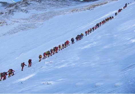 |
| Image from eightsummits.com depicting the crowds on the South Col route. |
Traffic on the route. These lines are dangerous. Unlike traffic back-ups in driving, the climbing log jams on Everest make the ascents much longer for all climbers and result in a greater likelihood of frostbite and hypothermia. Not only are climbers likely to get cold but also they are more likely to waste precious energy just waiting around in between steps. More waiting means more energy consumed for the same route. Climbers get sick or tired or both when waiting. There are many ways to prevent these traffic jams but most are ignored by the Nepali government, climbing teams, and Sherpa. We all want to climb and it just turns into a mess when there are too many climbers climbing up a one-way fixed route. Hopefully, the traffic will not be so great when I arrive late in the climbing season.
Camp 3. Once we ascend the fixed ropes up the Lohtse face, we arrive at Camp 3 - a little flat spot or sets of flat spots about half-way up to the South Col and just below the famed Yellow Band.
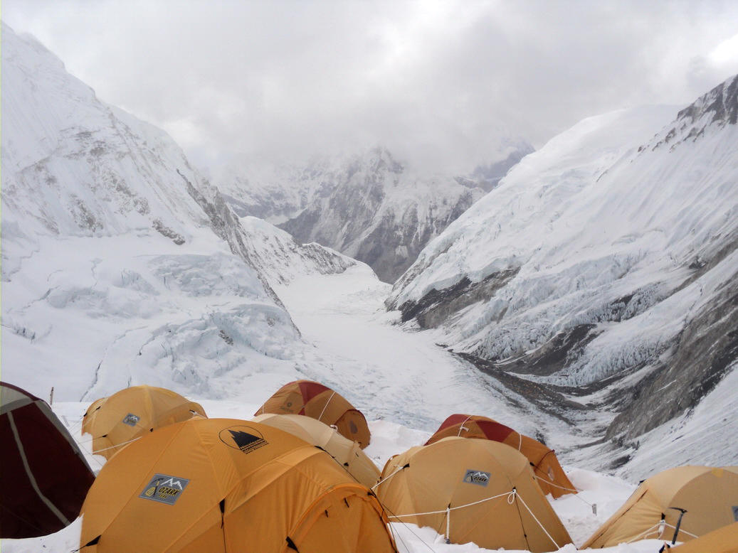 |
| Photo courtesy of Tom Claytor who summited Everest in 2010. |
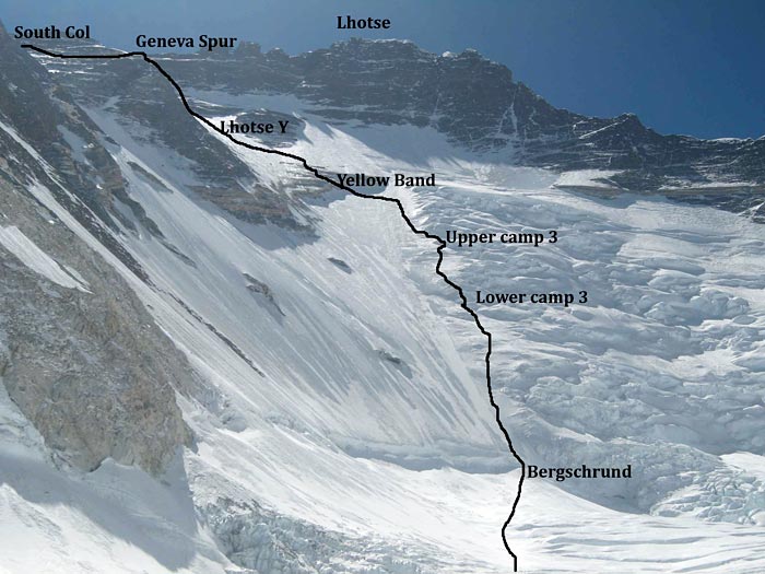 |
| Image copied from the IMG page documenting the South Col route up Everest. |
Yep, a brick. Great team and great support. Thanks all.

via Instagram https://instagram.com/p/1bKx7XQAWy/
Thursday, April 9, 2015
Documenting the climb - one section at a time (Camp 1 to Camp 2)
Greetings. As promised, I continue my posts about the climb. The second leg up the mountain presented more troubles for me than the first leg. More people take pictures and document the Khumbu icefall than any other section. The following tidbits are what I could gather about leg two between Camp 1 (19,600 feet or 6000m) to Camp 2 (21,000 feet or 6400m).
The Western Cwm (pronounced koom)
A U-shaped valley separates Camp 1 from Camp 2. We ascend 1,400 feet or 400m up through a protected valley where temperatures can soar into the upper 90's F (35+ C) due to the low winds and parabolic shape to the route. The surrounding mountains block the winds and the sun beats down on the glacial whiteness - combine those factors with the shape of the glacial path we walk upon results in extremely hot temperatures. Alan Arnette provided an excellent look at this valley in the picture posted below (Camp 1 is the top triangle and Camp 2 is the lower triangle - picture taken from Camp 3 on the Lohtse face):

As you can see from the picture above, the pitch of the climb appears rather gradual. This section of the climb is relatively flat. We ascend through the Western Cwm from Camp 1 to Camp 2 and gain roughly 1,400 feet (400m) in a slightly longer walking distance (1.7 miles) compared to the walking distance in the first leg between EBC and Camp 1 (1.6 miles). The primary difference between the two legs - aside from the pitch of the climb - is the duration of the climb (2-3 hours for leg 2 vs. 4-12 hours for leg 1) and the temperature. Temperatures vary greatly on the Western Cwm often shifting between freezing and scorching heat. Below is a nice, brief video of what the traverse looks like across the Western Cwm.
Once we reach Camp 2, we start to see the Lohtse face and our next leg that takes us up the face. Stay tuned for more information on that leg.
The Western Cwm (pronounced koom)
A U-shaped valley separates Camp 1 from Camp 2. We ascend 1,400 feet or 400m up through a protected valley where temperatures can soar into the upper 90's F (35+ C) due to the low winds and parabolic shape to the route. The surrounding mountains block the winds and the sun beats down on the glacial whiteness - combine those factors with the shape of the glacial path we walk upon results in extremely hot temperatures. Alan Arnette provided an excellent look at this valley in the picture posted below (Camp 1 is the top triangle and Camp 2 is the lower triangle - picture taken from Camp 3 on the Lohtse face):
As you can see from the picture above, the pitch of the climb appears rather gradual. This section of the climb is relatively flat. We ascend through the Western Cwm from Camp 1 to Camp 2 and gain roughly 1,400 feet (400m) in a slightly longer walking distance (1.7 miles) compared to the walking distance in the first leg between EBC and Camp 1 (1.6 miles). The primary difference between the two legs - aside from the pitch of the climb - is the duration of the climb (2-3 hours for leg 2 vs. 4-12 hours for leg 1) and the temperature. Temperatures vary greatly on the Western Cwm often shifting between freezing and scorching heat. Below is a nice, brief video of what the traverse looks like across the Western Cwm.
Once we reach Camp 2, we start to see the Lohtse face and our next leg that takes us up the face. Stay tuned for more information on that leg.
Monday, April 6, 2015
Documenting the climb - one section at a time (EBC to Camp 1)
A thought occurred to me the other day that while I am playing the waiting game, I might as well provide some details about the climb. These details allow me to immerse myself into the climb and envision what each section has in store for me. Today, I provide some details about the first leg of the climb from Everest Base Camp (EBC; 17,600 feet or 5400m) to Camp 1 (19,600 feet or 6000m).
Let me begin by providing some key terms that will help you better understand the routes and changes. When I say "old route," I mean the route that was used last year and for roughly 10 years prior to last year. This "old route" is really new compared to the route used by the original expeditions. Now, when I say "new route," I mean the route that will be used this year. That route is the route that was preferred by expeditions prior to the early or mid-1990's. Regardless, the "old" is "new" and the "new" is now "old." You get the point (I hope). OK, moving forward....
Many of you know about last year's tragedy (recounted by Himex's Russell Brice) where the hanging ice from the West Shoulder of Everest calved into the icefall. That event alone wouldn't be surprising but last year it happened when 16 Nepali workers and Sherpa were in the icefall. From that day forward, the climbing season effectively ended. Flash forward to this year where the SPCC (Sagarmatha Polution Control Committee) - the group that oversees the "Icefall Doctors" and the route selection - chose to veer away from the West Shoulder and toward Nuptse.
Let me give you a better sense of this shift by directing you to Garrett Madison's (of Madison Mountaineering) post that contrasts the old and new route. National geographic posted an excellent prescient (picture taken in April 2012) image that showed the dangers that awaited all climbers and an article discussing the dangers of the route. Here is that image posted below with full acknowledgements (Juan Velasco, National Geographic Staff. Photograph by Mark Jenkins):
From Garrett's picture and the National Geographic edited photo, you can see that the new route up the icefall shifts right (climber's right) and away from the West Shoulder. The change does introduce some new hurdles - so to speak. Let me discuss each in turn and then return to some estimates of climbing through the icefall.
What made the "old route" the preferred route for some time (10+ years)?
For many years, the route ran through the center of the Khumbu icefall (prior to the mid-90's). Climbers had to overcome large vertical sections and found the going up the route slow and taxing. Climbing up ladders makes for slow going and often creates "log jams" of climbers waiting for slower climbers ahead of them. By shifting the climb away from the center and more toward the left (climbers left), climbers were able to navigate the icefall in far less time with far less effort. Thus, this year's "old route" - the one used last year if you are following my twisted logic - turned out to be a time and effort saver. Those savings came at a cost.
What were those costs attributable to the "old route" you mention above?
As with all changes, there are costs and benefits. A more direct route that requires greater effort and time to overcome due to vertical climbs and larger crevasse spans must provide some benefit. That benefit is safety from snow, ice and rock. As the route drifted closer to the left side of the icefall, the danger of falling debris increased substantially. Snow (via avalanche), ice (via ice calving), and rock (via land slides - not typical in the winter) all pose a threat to climbers below the West Shoulder that overlooks the left side of the icefall. Thus, the "old" route had risks that the "new" route minimizes.
Time estimates for both routes
The "new" route introduces some obstacles that ought to increase the time demands - and, as a result, the energy demands - on the climbers. That increase cannot be estimated until we have climbers going up the route. If you want to see an awesome video of the icefall climb, please watch the one below. You'll see climbers ascending and descending ladders to climb the icefall. Yes, we go up and down ladders because the ice undulates through the icefall and we need to navigate those undulations.
So how long does it take? Every climber takes their time the first round. They make sure they have their gear setup correctly, climbs with a minimal amount of weight, and properly (we hope) assesses the risk of each section. These precautions take time. Some people estimate the time for the icefall route - regardless of "old" or "new" to be between 8 and 12 hours. Some Sherpa take 2-4 hours and run through the icefall. Who can blame them? Thus, the time span can be between 2 and 12 hours. Faster climbers who are adept at navigating the ladders and bridges take far less time. If there are many areas where log jams occur, I suspect there will be huge time costs and my estimates may be way off.
Once a climber gets through the icefall, the only remaining step is to cross a few open crevasse to Camp 1 (roughly 19,600 feet or 6000 m) where we sleep for a night and then probably descend down to EBC the next morning. So consider this point. We climb 2000 feet or roughly 600 meters in a span of 2 to 12 hours. This section of the climb probably offers the greatest variability in terms of time and effort since we all navigate the icefall multiple times. As we get more acclimatized, we move faster and those times drop considerably - at least they ought to drop. No other area on the mountain gets the same traffic as this section and none offer the opportunity to improve with each pass.
My next post documents the brief trip between Camp 1 (19,600 feet or 6000m) and Camp 2 (21,300 feet or 6500m).
Let me begin by providing some key terms that will help you better understand the routes and changes. When I say "old route," I mean the route that was used last year and for roughly 10 years prior to last year. This "old route" is really new compared to the route used by the original expeditions. Now, when I say "new route," I mean the route that will be used this year. That route is the route that was preferred by expeditions prior to the early or mid-1990's. Regardless, the "old" is "new" and the "new" is now "old." You get the point (I hope). OK, moving forward....
Many of you know about last year's tragedy (recounted by Himex's Russell Brice) where the hanging ice from the West Shoulder of Everest calved into the icefall. That event alone wouldn't be surprising but last year it happened when 16 Nepali workers and Sherpa were in the icefall. From that day forward, the climbing season effectively ended. Flash forward to this year where the SPCC (Sagarmatha Polution Control Committee) - the group that oversees the "Icefall Doctors" and the route selection - chose to veer away from the West Shoulder and toward Nuptse.
Let me give you a better sense of this shift by directing you to Garrett Madison's (of Madison Mountaineering) post that contrasts the old and new route. National geographic posted an excellent prescient (picture taken in April 2012) image that showed the dangers that awaited all climbers and an article discussing the dangers of the route. Here is that image posted below with full acknowledgements (Juan Velasco, National Geographic Staff. Photograph by Mark Jenkins):
 |
| Photo by Mark Jenkins and edited by Juan Velasco of NG |
What made the "old route" the preferred route for some time (10+ years)?
For many years, the route ran through the center of the Khumbu icefall (prior to the mid-90's). Climbers had to overcome large vertical sections and found the going up the route slow and taxing. Climbing up ladders makes for slow going and often creates "log jams" of climbers waiting for slower climbers ahead of them. By shifting the climb away from the center and more toward the left (climbers left), climbers were able to navigate the icefall in far less time with far less effort. Thus, this year's "old route" - the one used last year if you are following my twisted logic - turned out to be a time and effort saver. Those savings came at a cost.
What were those costs attributable to the "old route" you mention above?
As with all changes, there are costs and benefits. A more direct route that requires greater effort and time to overcome due to vertical climbs and larger crevasse spans must provide some benefit. That benefit is safety from snow, ice and rock. As the route drifted closer to the left side of the icefall, the danger of falling debris increased substantially. Snow (via avalanche), ice (via ice calving), and rock (via land slides - not typical in the winter) all pose a threat to climbers below the West Shoulder that overlooks the left side of the icefall. Thus, the "old" route had risks that the "new" route minimizes.
Time estimates for both routes
The "new" route introduces some obstacles that ought to increase the time demands - and, as a result, the energy demands - on the climbers. That increase cannot be estimated until we have climbers going up the route. If you want to see an awesome video of the icefall climb, please watch the one below. You'll see climbers ascending and descending ladders to climb the icefall. Yes, we go up and down ladders because the ice undulates through the icefall and we need to navigate those undulations.
So how long does it take? Every climber takes their time the first round. They make sure they have their gear setup correctly, climbs with a minimal amount of weight, and properly (we hope) assesses the risk of each section. These precautions take time. Some people estimate the time for the icefall route - regardless of "old" or "new" to be between 8 and 12 hours. Some Sherpa take 2-4 hours and run through the icefall. Who can blame them? Thus, the time span can be between 2 and 12 hours. Faster climbers who are adept at navigating the ladders and bridges take far less time. If there are many areas where log jams occur, I suspect there will be huge time costs and my estimates may be way off.
Once a climber gets through the icefall, the only remaining step is to cross a few open crevasse to Camp 1 (roughly 19,600 feet or 6000 m) where we sleep for a night and then probably descend down to EBC the next morning. So consider this point. We climb 2000 feet or roughly 600 meters in a span of 2 to 12 hours. This section of the climb probably offers the greatest variability in terms of time and effort since we all navigate the icefall multiple times. As we get more acclimatized, we move faster and those times drop considerably - at least they ought to drop. No other area on the mountain gets the same traffic as this section and none offer the opportunity to improve with each pass.
My next post documents the brief trip between Camp 1 (19,600 feet or 6000m) and Camp 2 (21,300 feet or 6500m).
Sunday, April 5, 2015
Some choice albums (discs, mp3's or whatever) that help me trek into basecamp...Volume 2
Back for more? Here goes with my extended dance version - actually, I don't dance. No rhythm. I tap out a good tune with my feet though as I sip down my beer. Does that count? OK, here are some other albums I typically listen to while climbing...
The Band - all albums but I particularly like this one (2 discs) and their older stuff.

Bob Dylan - my favorites are Desire and Blood on the Tracks. There are countless albums I listen to all the time but these are the two I come back to most often.

The Fray - I generally like all their albums and listen to them on shuffle.


Neil Young - I have no favorites; I like all his albums. In particular, I grew up with Comes a Time and listen to that one often...along with Harvest.

The Rolling Stones - love all their stuff. The one album that gets played more than any other is Exile on Main Street - a classic in my life:

Dave Matthews (Band and Solo) - my personal favorite and the one that always gets cued up on long airplane trips and fun hikes is his solo album Some Devil:

Billy Joel - Songs in the Attic - simply a classic in my lifetime. I grew up listening to these songs and they remain a staple when I am mindlessly working:

The Who - Quadrophenia and Tommy in particular - these are my staples when I am just chilling out in my tent. I love Quadrophenia. It is a part of me and gets me pumped up for life. Yeah, I know, I'm weird. Who isn't?

Van Morrison - another personal favorite. I listen to all his albums but one of my favorites is The Best of... because it gives me a taste of many of his tunes. Yeah, Moondance gets played a ton too.

Crosby, Stills, Nash & Young - I'm a huge fan of their music and nowadays I tend to listen to Deja Vu more frequently than others:

Maroon 5 - I really enjoy rocking out to Adam Levine. Yeah, most of his songs kinda blend together but I like 'em all. Here is my personal favorite (if I have one):

The Finn Brothers - the front men for Crowded House created an awesome and unappreciated album (Everyone is Here) that just grabs me and keeps me thinking:

The Waterboys - a classic Irish edgy folk-rock band that my friend Matt Johnson turned me onto many years ago. My personal favorite is Fisherman's Blues:

Led Zepplin - all of it - for those of us who grew up in the early 70's, it is hard to avoid this band. They were part of my growing up and I still listen to them - mostly via compilations or randomly shuffling through all their music:

Kings of Leon - I got hooked on this band when they came out with their blockbuster album Only by the Night but since that one, I purchased all their other albums and listen to them religiously:

Coldplay - I like all their music but I particularly like Parachutes. Not sure why. I just do.

Bob Marley and the Wailers - I love Bob. My brain knows Legend in the order of the songs and expects them to be played in that order. Maybe too much Bob at a certain time in my life.

Train - I love all their stuff. They have catchy tunes that keep me motivated. Here is one of my favorites:

That about wraps it up. Some of you may ask...what? No Eagles, Doors, Beatles, Elton John, or more contemporary stuff? Nope. I listen to them all but I can only fit 64 GB onto my micro SD card so I need to choose carefully.
Subscribe to:
Posts (Atom)