 |
| My 2015 Everest Permit |

In April 2014, I attempted to climb Mt. Everest before an avalanche in the icefall claimed the lives of 18 Sherpa. A year later (May 2015), I returned to Mt. Everest only to witness a 7.8 earthquake while at camp 1. I am preparing to climb again in April 2018 but this blog is dedicated to my purposeful pursuits. Please be sure to check out the charities that I support and follow me on twitter (@pem725) or instagram (pem725).
Tuesday, April 14, 2015
Hey, look what came in the (e)mail today....

Documenting the climb - one section at a time (Camp 3 to the Everest Summit)
Greetings. I trust this post finds you all well. All is well with me as I prepare to leave. Today, I post my final leg of the climb and then wrap up the climb with an awesome graphic and two videos worth watching. As I read through my blog after the last post, I came to the realization that some people may think that I am actually climbing right now. Rest assured, I am sitting in my kitchen typing this post. Things are going pretty well in Nepal right now but I sure am happy to be in Fairfax, VA, eating my own food, and staying healthy. I feel great. I am eating a ton and gaining weight to the point where I might actually leave at my goal of 180 lbs (81.6 kg). So far, so good. OK, the last leg of the climb...
Camp 3 (23,500 feet or 7160 m) to the Summit (29,029 feet or 8,848 m)
The Yellow Band (top at 25,000 feet or 7620 m: 1-3 hours from Camp 3). The push up from Camp 3 starts as a rapid ascent to the Yellow Band - a strip of sedimentary sandstone rock that appears yellow from all angles. Here (below) is a good picture of the Yellow Band:
More on the Yellow Band.... For those of you who are interested in the geology of Everest, I highly recommend you watch this brief video below.
In the video, Dave Lageson - a geology professor at Montana State University - describes the composition of the Yellow Band. He along with team leader Conrad Anker, climbed Mt. Everest in 2012 with a team from the Everest Education Expedition. Watch the video and check out Dave's other educational materials if you find this topic interesting. OK, back to the route.
Dry Tooling. You can clearly see that the Yellow Band is a stark departure from the glacier travel that we covered over the past three legs. Finally, some rock! Of course, that departure from the normal glacier creates some problems for climbers who are not accustomed to "dry tooling" on rock. The Yellow Band is brief (100m of rope at the most to traverse it) and does not require too much energy to overcome these days due to fixed ropes and well packed down routes where snow may exist. Also, there is little vertical gained during the crossing of the Yellow Band. We simply traverse the route to aim toward the next objective.
The Geneva Spur (25,500 feet or 7,772 m - 1-2 hours from the Yellow Band). Once past the Yellow Band, we head up past the point where the Lohtse climbers bear to the right while we Everest climbers climb on toward the Geneva Spur. Here is an excellent image of what the spur looks like (see below):
The Geneva Spur - like the Yellow Band - consists of a mixture of rock and ice. During years when the snowfall is particularly heavy, the Geneva spur may have loose snow that inhibits climbers from climbing quickly past this section. At this point, climbers usually take between 2 and 5 hours to reach the Geneva Spur from Camp 3 - the faster ones do it in 2 hours while others who take their time or struggle with the thin air may take as many as 5 hours.
South Col or Camp 4 (26,400 feet or 8000 m: about 1 hour from the Geneva Spur). Passing the Geneva Spur and pressing onward, climbers approach the South Col in about an hour. The South Col is where climbers enter "The Death Zone" or the altitude where climbers' bodies cannot sustain life. At the Col - a flat portion of the climb that forms the saddle between Everest and Lohtse - some expeditions setup a camp to allow tired climbers to rest and recover from the 3-6 hours of high altitude climbing. The South Col is a windy place that offers very little shelter from Everest's brutal conditions. Below is an excellent photo from the South Col. You can see that most climbers use oxygen at this point. Also, you'll notice a huge cache of oxygen bottles - most full and ready for climbers who pass by the Col and head up towards the summit.
Life at the South Col can be quite taxing. Climbers struggle to recover and there is little rest that awaits us. Breathing oxygen through a mask makes for an awkward nap - even for the most fatigued climbers. A brief break of a few hours, however, affords climbers to fuel up, drink plenty of fluids, and ready themselves for the summit push. Climbers start their summit push here usually either late at night (11pm) or really early in the morning (3 am) - all dependent upon their speed and acclimatization. More on that point later.
"The Balcony" (27,500 feet or 8380 m: 3-6 hours from the South Col). Climbers leave the South Col and head up the Triangular Face toward "The Balcony" - a small platform used by many expeditions to cache equipment, to take a brief rest before pushing upwards, and, of course, to take pictures of nearby peaks. Here (below) is an excellent video that shows the views from the Balcony.
Adding to that great video footage is an excellent picture that shows the first part of the ascent from the South Col.
The section of the climb called "The Balcony" gets its name from the obvious point that it represents an optimal viewing location for the area surrounding Everest. I am not sure who named it but its name seems appropriate. Next step....
The South Summit (28,500 feet or 8690m: 3-5 hours from "The Balcony"). The ascent up takes us now to the South Summit Ridge where the real summit push begins in earnest. Climbers flagging at this point should turn around because this section can really test the resolve of even the most dedicated climber. Here, there is a well-worn path with fixed ropes that takes you up to the summit. Getting to this point, however, takes some time. Below is a picture from the South Summit upwards to the Hilary Step and then onwards to the summit.
The ascent up from the Balcony is rather steep. Below is a picture taken from the South Summit downwards to the Balcony. As you can see, the climbers work their way up a ridge of rock, following in the footsteps of the climbers who preceded them that day (or week).
That long slog upwards gets rewarded by some amazing views. Climbers can see the summit ridge, the Hilary step, and the summit. Now, the possibility of a successful summit is within reach.
The Hillary Step (28,740 feet or 8760 m: less than an hour from the South Summit). A brief push up from the South Summit lies the famous Hillary Step named after famed New Zealand mountaineer who climbed Mt. Everest for the first time in 1953 with Tenzing Norgay. I guess only Hillary got the benefit of a route obstacle named after him. At any rate, the Hillary Step offers the last major hurdle for the climber to reach the summit.
Climbing up the Hillary Step can be taxing. Just listen to Apa Sherpa as he climbs the route for his 18th time (in 2008).
The Summit! (29,029 feet or 8848 m; about an hour from the Hillary Step). Yes! We made it to the summit. From the South Col, a climber can expect the summit push to take between 7 and 14 hours just to reach the top. Typically, wise, seasoned climbers use a cut-off of 3pm (local time) to get off the summit. If a climber leaves the South Col at midnight and they take 14 hours to reach the summit, that climber has a 1-hour safety period (2pm arrival at the summit). Thus, the forecast for a climber's speed can be a vital element in a successful summit attempt. Climbers who climb slower than their window of opportunity ought to turn around prior to reaching the summit or risk the threat of not making the return trip. Many people make that mistake and find themselves in trouble and without any possibility of help. There are no rescues from this elevation; every climber is on his/her own.
OK, enough drama. Here is a great picture from the summit of the world. It is only fitting that I use one of Dan Mazur's pictures from his SummitClimb website to cap off this wild ride up the South Col route to the Mt. Everest summit.
So now you know the route. Follow along with me while I attempt to climb it. It should be a fun ride for us all.
A recap from Camp 2
For a full recap, listen to Kenton Cool describe the summit route from Camp 2 upwards. He provides a really nice summary of the points I described in detail above. Kenton adds a certain bit of color that might be absent in the writing above. I recommend you watch these videos for an expert's perspective.
Video 1
Video 2
A full summary
Another good perspective of the entire climb is to look at an elevation map where the altitude gets plotted as a function of the days on the mountain. Below is one example of an elevation map.
I hope you found this multiple-post route summary to be useful; it was useful for me to visualize my upcoming objective. These route summaries help me identify landmarks and create milestone goals for these long, hard pushes.
Expect two more posts before I push off for Kathmandu shortly. See you soon....
Camp 3 (23,500 feet or 7160 m) to the Summit (29,029 feet or 8,848 m)
The Yellow Band (top at 25,000 feet or 7620 m: 1-3 hours from Camp 3). The push up from Camp 3 starts as a rapid ascent to the Yellow Band - a strip of sedimentary sandstone rock that appears yellow from all angles. Here (below) is a good picture of the Yellow Band:
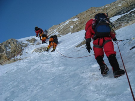 |
| Image from Valerio Massimo Everest Expedition 2009 |
In the video, Dave Lageson - a geology professor at Montana State University - describes the composition of the Yellow Band. He along with team leader Conrad Anker, climbed Mt. Everest in 2012 with a team from the Everest Education Expedition. Watch the video and check out Dave's other educational materials if you find this topic interesting. OK, back to the route.
Dry Tooling. You can clearly see that the Yellow Band is a stark departure from the glacier travel that we covered over the past three legs. Finally, some rock! Of course, that departure from the normal glacier creates some problems for climbers who are not accustomed to "dry tooling" on rock. The Yellow Band is brief (100m of rope at the most to traverse it) and does not require too much energy to overcome these days due to fixed ropes and well packed down routes where snow may exist. Also, there is little vertical gained during the crossing of the Yellow Band. We simply traverse the route to aim toward the next objective.
The Geneva Spur (25,500 feet or 7,772 m - 1-2 hours from the Yellow Band). Once past the Yellow Band, we head up past the point where the Lohtse climbers bear to the right while we Everest climbers climb on toward the Geneva Spur. Here is an excellent image of what the spur looks like (see below):
 |
| Image from Landtarget blog taken in 2008. |
South Col or Camp 4 (26,400 feet or 8000 m: about 1 hour from the Geneva Spur). Passing the Geneva Spur and pressing onward, climbers approach the South Col in about an hour. The South Col is where climbers enter "The Death Zone" or the altitude where climbers' bodies cannot sustain life. At the Col - a flat portion of the climb that forms the saddle between Everest and Lohtse - some expeditions setup a camp to allow tired climbers to rest and recover from the 3-6 hours of high altitude climbing. The South Col is a windy place that offers very little shelter from Everest's brutal conditions. Below is an excellent photo from the South Col. You can see that most climbers use oxygen at this point. Also, you'll notice a huge cache of oxygen bottles - most full and ready for climbers who pass by the Col and head up towards the summit.
 |
| Photo from Scott Simper Productions and taken in 2013. |
"The Balcony" (27,500 feet or 8380 m: 3-6 hours from the South Col). Climbers leave the South Col and head up the Triangular Face toward "The Balcony" - a small platform used by many expeditions to cache equipment, to take a brief rest before pushing upwards, and, of course, to take pictures of nearby peaks. Here (below) is an excellent video that shows the views from the Balcony.
 |
| Photo from Everest Hip Hop Expedition in 2010. |
The South Summit (28,500 feet or 8690m: 3-5 hours from "The Balcony"). The ascent up takes us now to the South Summit Ridge where the real summit push begins in earnest. Climbers flagging at this point should turn around because this section can really test the resolve of even the most dedicated climber. Here, there is a well-worn path with fixed ropes that takes you up to the summit. Getting to this point, however, takes some time. Below is a picture from the South Summit upwards to the Hilary Step and then onwards to the summit.
 |
| Photo from Ian Rogers' Climb4Life website and expedition in 2009. |
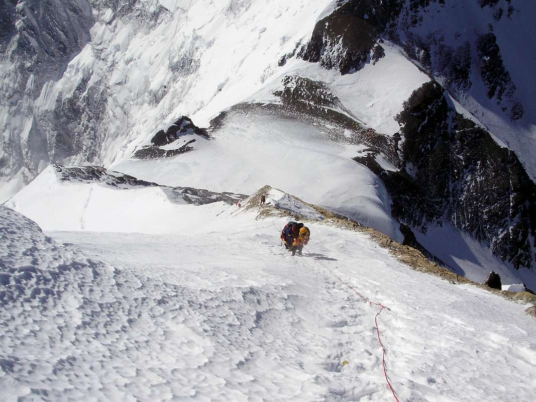 |
| Photo from Summitpost.org. |
The Hillary Step (28,740 feet or 8760 m: less than an hour from the South Summit). A brief push up from the South Summit lies the famous Hillary Step named after famed New Zealand mountaineer who climbed Mt. Everest for the first time in 1953 with Tenzing Norgay. I guess only Hillary got the benefit of a route obstacle named after him. At any rate, the Hillary Step offers the last major hurdle for the climber to reach the summit.
 |
| The Hillary Step. Photo appeared in the blog livefortheoutdoors.com. |
The Summit! (29,029 feet or 8848 m; about an hour from the Hillary Step). Yes! We made it to the summit. From the South Col, a climber can expect the summit push to take between 7 and 14 hours just to reach the top. Typically, wise, seasoned climbers use a cut-off of 3pm (local time) to get off the summit. If a climber leaves the South Col at midnight and they take 14 hours to reach the summit, that climber has a 1-hour safety period (2pm arrival at the summit). Thus, the forecast for a climber's speed can be a vital element in a successful summit attempt. Climbers who climb slower than their window of opportunity ought to turn around prior to reaching the summit or risk the threat of not making the return trip. Many people make that mistake and find themselves in trouble and without any possibility of help. There are no rescues from this elevation; every climber is on his/her own.
OK, enough drama. Here is a great picture from the summit of the world. It is only fitting that I use one of Dan Mazur's pictures from his SummitClimb website to cap off this wild ride up the South Col route to the Mt. Everest summit.
 |
| Photo by David O'Brien who summited on May 23rd, 2013 |
So now you know the route. Follow along with me while I attempt to climb it. It should be a fun ride for us all.
A recap from Camp 2
For a full recap, listen to Kenton Cool describe the summit route from Camp 2 upwards. He provides a really nice summary of the points I described in detail above. Kenton adds a certain bit of color that might be absent in the writing above. I recommend you watch these videos for an expert's perspective.
Video 1
Video 2
A full summary
Another good perspective of the entire climb is to look at an elevation map where the altitude gets plotted as a function of the days on the mountain. Below is one example of an elevation map.
 |
| Image from climb8850.com blog. |
Expect two more posts before I push off for Kathmandu shortly. See you soon....
Monday, April 13, 2015
Documenting the climb - one section at a time (Camp 2 to Camp 3)
Greetings again. Just a little time left at home before I depart. I continue with my posts about the South Col route up to the Everest summit. Before I continue, I want to draw your attention to the new "widget" on the right side of my blog where you may sign up for email alerts when I post. Many of you received email messages before when I posted new blog entries but Google bans large email distribution alerts from my side. Thus, you must subscribe to the email alerts if you wish to receive them from now on. I hope you find these posts useful...
OK, onward and upward towards the summit.
Camp 2 (21,000 feet or 6400 m) to Camp 3 (23,500 feet or 7160m) represents a big push in altitude (2,500 feet or 760m) over a relatively short distance (1.64 miles). That change in altitude comes from ascending the Lohtse face. Below is an excellent image courtesy of the Alpinist.com:

As you can see from the picture above, the route starts off pretty flat - actually a gradual uphill section to the Lohtse face. At the junction between the flat section and the face lies the bergshrund on the route at about 22,000 feet (6700m). The bergschrund is the section of the glacier where the moving part of the glacier begins - moving downwards obviously - and the permanent or stagnant ice/loose snowpack - also called firn - lies above that moving part. You can see in the image above that the bergschrund presents a challenge for climbers to overcome a large crack or crevasse. Once climbers get past the bergschrund, they must ascend the Lohtse face via fixed ropes. In truth, there is nothing that mandates climbers use the fixed ropes and some elite alpinists avoid them at all costs to preserve their pristine ascent and avoid the traffic jams that frequently occur on the fixed ropes. The rest of us mere mortals grab the fixed ropes, lock in our ascenders, and climb the route like a centipede with climbers streaming up along the entire route.
Yep, it is this part of the route where the real traffic jams start. I mentioned earlier about the potential for crowds or log jams to take place in the Khumbu icefall. Here on the Lohtse face is where the potential becomes a reality.
Traffic on the route. These lines are dangerous. Unlike traffic back-ups in driving, the climbing log jams on Everest make the ascents much longer for all climbers and result in a greater likelihood of frostbite and hypothermia. Not only are climbers likely to get cold but also they are more likely to waste precious energy just waiting around in between steps. More waiting means more energy consumed for the same route. Climbers get sick or tired or both when waiting. There are many ways to prevent these traffic jams but most are ignored by the Nepali government, climbing teams, and Sherpa. We all want to climb and it just turns into a mess when there are too many climbers climbing up a one-way fixed route. Hopefully, the traffic will not be so great when I arrive late in the climbing season.
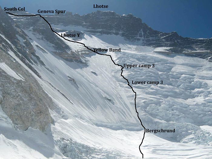
Camp 3. Once we ascend the fixed ropes up the Lohtse face, we arrive at Camp 3 - a little flat spot or sets of flat spots about half-way up to the South Col and just below the famed Yellow Band.
IMG posted an excellent route map of this section and the sections above. Below is that image for a better understanding of where Camp 3 spans the route:
Camp 3 is not a fixed location but rather a span of flat spaces that fall just below the Yellow Band. Once climbers reach Camp 3, they are ready to press on above and into the "Death Zone" that begins at 8000 meters (26,250 feet). Stay tuned for that portion of the climb where I document the summit push from Camp 3 up to the summit. It is a wild ride.
OK, onward and upward towards the summit.
Camp 2 (21,000 feet or 6400 m) to Camp 3 (23,500 feet or 7160m) represents a big push in altitude (2,500 feet or 760m) over a relatively short distance (1.64 miles). That change in altitude comes from ascending the Lohtse face. Below is an excellent image courtesy of the Alpinist.com:

As you can see from the picture above, the route starts off pretty flat - actually a gradual uphill section to the Lohtse face. At the junction between the flat section and the face lies the bergshrund on the route at about 22,000 feet (6700m). The bergschrund is the section of the glacier where the moving part of the glacier begins - moving downwards obviously - and the permanent or stagnant ice/loose snowpack - also called firn - lies above that moving part. You can see in the image above that the bergschrund presents a challenge for climbers to overcome a large crack or crevasse. Once climbers get past the bergschrund, they must ascend the Lohtse face via fixed ropes. In truth, there is nothing that mandates climbers use the fixed ropes and some elite alpinists avoid them at all costs to preserve their pristine ascent and avoid the traffic jams that frequently occur on the fixed ropes. The rest of us mere mortals grab the fixed ropes, lock in our ascenders, and climb the route like a centipede with climbers streaming up along the entire route.
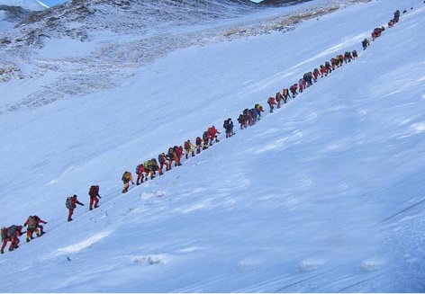 |
| Image from eightsummits.com depicting the crowds on the South Col route. |
Traffic on the route. These lines are dangerous. Unlike traffic back-ups in driving, the climbing log jams on Everest make the ascents much longer for all climbers and result in a greater likelihood of frostbite and hypothermia. Not only are climbers likely to get cold but also they are more likely to waste precious energy just waiting around in between steps. More waiting means more energy consumed for the same route. Climbers get sick or tired or both when waiting. There are many ways to prevent these traffic jams but most are ignored by the Nepali government, climbing teams, and Sherpa. We all want to climb and it just turns into a mess when there are too many climbers climbing up a one-way fixed route. Hopefully, the traffic will not be so great when I arrive late in the climbing season.
Camp 3. Once we ascend the fixed ropes up the Lohtse face, we arrive at Camp 3 - a little flat spot or sets of flat spots about half-way up to the South Col and just below the famed Yellow Band.
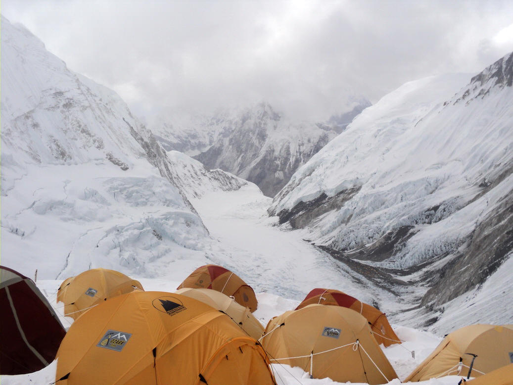 |
| Photo courtesy of Tom Claytor who summited Everest in 2010. |
 |
| Image copied from the IMG page documenting the South Col route up Everest. |
Yep, a brick. Great team and great support. Thanks all.

via Instagram https://instagram.com/p/1bKx7XQAWy/
Thursday, April 9, 2015
Documenting the climb - one section at a time (Camp 1 to Camp 2)
Greetings. As promised, I continue my posts about the climb. The second leg up the mountain presented more troubles for me than the first leg. More people take pictures and document the Khumbu icefall than any other section. The following tidbits are what I could gather about leg two between Camp 1 (19,600 feet or 6000m) to Camp 2 (21,000 feet or 6400m).
The Western Cwm (pronounced koom)
A U-shaped valley separates Camp 1 from Camp 2. We ascend 1,400 feet or 400m up through a protected valley where temperatures can soar into the upper 90's F (35+ C) due to the low winds and parabolic shape to the route. The surrounding mountains block the winds and the sun beats down on the glacial whiteness - combine those factors with the shape of the glacial path we walk upon results in extremely hot temperatures. Alan Arnette provided an excellent look at this valley in the picture posted below (Camp 1 is the top triangle and Camp 2 is the lower triangle - picture taken from Camp 3 on the Lohtse face):

As you can see from the picture above, the pitch of the climb appears rather gradual. This section of the climb is relatively flat. We ascend through the Western Cwm from Camp 1 to Camp 2 and gain roughly 1,400 feet (400m) in a slightly longer walking distance (1.7 miles) compared to the walking distance in the first leg between EBC and Camp 1 (1.6 miles). The primary difference between the two legs - aside from the pitch of the climb - is the duration of the climb (2-3 hours for leg 2 vs. 4-12 hours for leg 1) and the temperature. Temperatures vary greatly on the Western Cwm often shifting between freezing and scorching heat. Below is a nice, brief video of what the traverse looks like across the Western Cwm.
Once we reach Camp 2, we start to see the Lohtse face and our next leg that takes us up the face. Stay tuned for more information on that leg.
The Western Cwm (pronounced koom)
A U-shaped valley separates Camp 1 from Camp 2. We ascend 1,400 feet or 400m up through a protected valley where temperatures can soar into the upper 90's F (35+ C) due to the low winds and parabolic shape to the route. The surrounding mountains block the winds and the sun beats down on the glacial whiteness - combine those factors with the shape of the glacial path we walk upon results in extremely hot temperatures. Alan Arnette provided an excellent look at this valley in the picture posted below (Camp 1 is the top triangle and Camp 2 is the lower triangle - picture taken from Camp 3 on the Lohtse face):
As you can see from the picture above, the pitch of the climb appears rather gradual. This section of the climb is relatively flat. We ascend through the Western Cwm from Camp 1 to Camp 2 and gain roughly 1,400 feet (400m) in a slightly longer walking distance (1.7 miles) compared to the walking distance in the first leg between EBC and Camp 1 (1.6 miles). The primary difference between the two legs - aside from the pitch of the climb - is the duration of the climb (2-3 hours for leg 2 vs. 4-12 hours for leg 1) and the temperature. Temperatures vary greatly on the Western Cwm often shifting between freezing and scorching heat. Below is a nice, brief video of what the traverse looks like across the Western Cwm.
Once we reach Camp 2, we start to see the Lohtse face and our next leg that takes us up the face. Stay tuned for more information on that leg.
Monday, April 6, 2015
Documenting the climb - one section at a time (EBC to Camp 1)
A thought occurred to me the other day that while I am playing the waiting game, I might as well provide some details about the climb. These details allow me to immerse myself into the climb and envision what each section has in store for me. Today, I provide some details about the first leg of the climb from Everest Base Camp (EBC; 17,600 feet or 5400m) to Camp 1 (19,600 feet or 6000m).
Let me begin by providing some key terms that will help you better understand the routes and changes. When I say "old route," I mean the route that was used last year and for roughly 10 years prior to last year. This "old route" is really new compared to the route used by the original expeditions. Now, when I say "new route," I mean the route that will be used this year. That route is the route that was preferred by expeditions prior to the early or mid-1990's. Regardless, the "old" is "new" and the "new" is now "old." You get the point (I hope). OK, moving forward....
Many of you know about last year's tragedy (recounted by Himex's Russell Brice) where the hanging ice from the West Shoulder of Everest calved into the icefall. That event alone wouldn't be surprising but last year it happened when 16 Nepali workers and Sherpa were in the icefall. From that day forward, the climbing season effectively ended. Flash forward to this year where the SPCC (Sagarmatha Polution Control Committee) - the group that oversees the "Icefall Doctors" and the route selection - chose to veer away from the West Shoulder and toward Nuptse.
Let me give you a better sense of this shift by directing you to Garrett Madison's (of Madison Mountaineering) post that contrasts the old and new route. National geographic posted an excellent prescient (picture taken in April 2012) image that showed the dangers that awaited all climbers and an article discussing the dangers of the route. Here is that image posted below with full acknowledgements (Juan Velasco, National Geographic Staff. Photograph by Mark Jenkins):
From Garrett's picture and the National Geographic edited photo, you can see that the new route up the icefall shifts right (climber's right) and away from the West Shoulder. The change does introduce some new hurdles - so to speak. Let me discuss each in turn and then return to some estimates of climbing through the icefall.
What made the "old route" the preferred route for some time (10+ years)?
For many years, the route ran through the center of the Khumbu icefall (prior to the mid-90's). Climbers had to overcome large vertical sections and found the going up the route slow and taxing. Climbing up ladders makes for slow going and often creates "log jams" of climbers waiting for slower climbers ahead of them. By shifting the climb away from the center and more toward the left (climbers left), climbers were able to navigate the icefall in far less time with far less effort. Thus, this year's "old route" - the one used last year if you are following my twisted logic - turned out to be a time and effort saver. Those savings came at a cost.
What were those costs attributable to the "old route" you mention above?
As with all changes, there are costs and benefits. A more direct route that requires greater effort and time to overcome due to vertical climbs and larger crevasse spans must provide some benefit. That benefit is safety from snow, ice and rock. As the route drifted closer to the left side of the icefall, the danger of falling debris increased substantially. Snow (via avalanche), ice (via ice calving), and rock (via land slides - not typical in the winter) all pose a threat to climbers below the West Shoulder that overlooks the left side of the icefall. Thus, the "old" route had risks that the "new" route minimizes.
Time estimates for both routes
The "new" route introduces some obstacles that ought to increase the time demands - and, as a result, the energy demands - on the climbers. That increase cannot be estimated until we have climbers going up the route. If you want to see an awesome video of the icefall climb, please watch the one below. You'll see climbers ascending and descending ladders to climb the icefall. Yes, we go up and down ladders because the ice undulates through the icefall and we need to navigate those undulations.
So how long does it take? Every climber takes their time the first round. They make sure they have their gear setup correctly, climbs with a minimal amount of weight, and properly (we hope) assesses the risk of each section. These precautions take time. Some people estimate the time for the icefall route - regardless of "old" or "new" to be between 8 and 12 hours. Some Sherpa take 2-4 hours and run through the icefall. Who can blame them? Thus, the time span can be between 2 and 12 hours. Faster climbers who are adept at navigating the ladders and bridges take far less time. If there are many areas where log jams occur, I suspect there will be huge time costs and my estimates may be way off.
Once a climber gets through the icefall, the only remaining step is to cross a few open crevasse to Camp 1 (roughly 19,600 feet or 6000 m) where we sleep for a night and then probably descend down to EBC the next morning. So consider this point. We climb 2000 feet or roughly 600 meters in a span of 2 to 12 hours. This section of the climb probably offers the greatest variability in terms of time and effort since we all navigate the icefall multiple times. As we get more acclimatized, we move faster and those times drop considerably - at least they ought to drop. No other area on the mountain gets the same traffic as this section and none offer the opportunity to improve with each pass.
My next post documents the brief trip between Camp 1 (19,600 feet or 6000m) and Camp 2 (21,300 feet or 6500m).
Let me begin by providing some key terms that will help you better understand the routes and changes. When I say "old route," I mean the route that was used last year and for roughly 10 years prior to last year. This "old route" is really new compared to the route used by the original expeditions. Now, when I say "new route," I mean the route that will be used this year. That route is the route that was preferred by expeditions prior to the early or mid-1990's. Regardless, the "old" is "new" and the "new" is now "old." You get the point (I hope). OK, moving forward....
Many of you know about last year's tragedy (recounted by Himex's Russell Brice) where the hanging ice from the West Shoulder of Everest calved into the icefall. That event alone wouldn't be surprising but last year it happened when 16 Nepali workers and Sherpa were in the icefall. From that day forward, the climbing season effectively ended. Flash forward to this year where the SPCC (Sagarmatha Polution Control Committee) - the group that oversees the "Icefall Doctors" and the route selection - chose to veer away from the West Shoulder and toward Nuptse.
Let me give you a better sense of this shift by directing you to Garrett Madison's (of Madison Mountaineering) post that contrasts the old and new route. National geographic posted an excellent prescient (picture taken in April 2012) image that showed the dangers that awaited all climbers and an article discussing the dangers of the route. Here is that image posted below with full acknowledgements (Juan Velasco, National Geographic Staff. Photograph by Mark Jenkins):
 |
| Photo by Mark Jenkins and edited by Juan Velasco of NG |
What made the "old route" the preferred route for some time (10+ years)?
For many years, the route ran through the center of the Khumbu icefall (prior to the mid-90's). Climbers had to overcome large vertical sections and found the going up the route slow and taxing. Climbing up ladders makes for slow going and often creates "log jams" of climbers waiting for slower climbers ahead of them. By shifting the climb away from the center and more toward the left (climbers left), climbers were able to navigate the icefall in far less time with far less effort. Thus, this year's "old route" - the one used last year if you are following my twisted logic - turned out to be a time and effort saver. Those savings came at a cost.
What were those costs attributable to the "old route" you mention above?
As with all changes, there are costs and benefits. A more direct route that requires greater effort and time to overcome due to vertical climbs and larger crevasse spans must provide some benefit. That benefit is safety from snow, ice and rock. As the route drifted closer to the left side of the icefall, the danger of falling debris increased substantially. Snow (via avalanche), ice (via ice calving), and rock (via land slides - not typical in the winter) all pose a threat to climbers below the West Shoulder that overlooks the left side of the icefall. Thus, the "old" route had risks that the "new" route minimizes.
Time estimates for both routes
The "new" route introduces some obstacles that ought to increase the time demands - and, as a result, the energy demands - on the climbers. That increase cannot be estimated until we have climbers going up the route. If you want to see an awesome video of the icefall climb, please watch the one below. You'll see climbers ascending and descending ladders to climb the icefall. Yes, we go up and down ladders because the ice undulates through the icefall and we need to navigate those undulations.
So how long does it take? Every climber takes their time the first round. They make sure they have their gear setup correctly, climbs with a minimal amount of weight, and properly (we hope) assesses the risk of each section. These precautions take time. Some people estimate the time for the icefall route - regardless of "old" or "new" to be between 8 and 12 hours. Some Sherpa take 2-4 hours and run through the icefall. Who can blame them? Thus, the time span can be between 2 and 12 hours. Faster climbers who are adept at navigating the ladders and bridges take far less time. If there are many areas where log jams occur, I suspect there will be huge time costs and my estimates may be way off.
Once a climber gets through the icefall, the only remaining step is to cross a few open crevasse to Camp 1 (roughly 19,600 feet or 6000 m) where we sleep for a night and then probably descend down to EBC the next morning. So consider this point. We climb 2000 feet or roughly 600 meters in a span of 2 to 12 hours. This section of the climb probably offers the greatest variability in terms of time and effort since we all navigate the icefall multiple times. As we get more acclimatized, we move faster and those times drop considerably - at least they ought to drop. No other area on the mountain gets the same traffic as this section and none offer the opportunity to improve with each pass.
My next post documents the brief trip between Camp 1 (19,600 feet or 6000m) and Camp 2 (21,300 feet or 6500m).
Sunday, April 5, 2015
Some choice albums (discs, mp3's or whatever) that help me trek into basecamp...Volume 2
Back for more? Here goes with my extended dance version - actually, I don't dance. No rhythm. I tap out a good tune with my feet though as I sip down my beer. Does that count? OK, here are some other albums I typically listen to while climbing...
The Band - all albums but I particularly like this one (2 discs) and their older stuff.

Bob Dylan - my favorites are Desire and Blood on the Tracks. There are countless albums I listen to all the time but these are the two I come back to most often.

The Fray - I generally like all their albums and listen to them on shuffle.


Neil Young - I have no favorites; I like all his albums. In particular, I grew up with Comes a Time and listen to that one often...along with Harvest.

The Rolling Stones - love all their stuff. The one album that gets played more than any other is Exile on Main Street - a classic in my life:

Dave Matthews (Band and Solo) - my personal favorite and the one that always gets cued up on long airplane trips and fun hikes is his solo album Some Devil:

Billy Joel - Songs in the Attic - simply a classic in my lifetime. I grew up listening to these songs and they remain a staple when I am mindlessly working:

The Who - Quadrophenia and Tommy in particular - these are my staples when I am just chilling out in my tent. I love Quadrophenia. It is a part of me and gets me pumped up for life. Yeah, I know, I'm weird. Who isn't?

Van Morrison - another personal favorite. I listen to all his albums but one of my favorites is The Best of... because it gives me a taste of many of his tunes. Yeah, Moondance gets played a ton too.

Crosby, Stills, Nash & Young - I'm a huge fan of their music and nowadays I tend to listen to Deja Vu more frequently than others:

Maroon 5 - I really enjoy rocking out to Adam Levine. Yeah, most of his songs kinda blend together but I like 'em all. Here is my personal favorite (if I have one):

The Finn Brothers - the front men for Crowded House created an awesome and unappreciated album (Everyone is Here) that just grabs me and keeps me thinking:

The Waterboys - a classic Irish edgy folk-rock band that my friend Matt Johnson turned me onto many years ago. My personal favorite is Fisherman's Blues:

Led Zepplin - all of it - for those of us who grew up in the early 70's, it is hard to avoid this band. They were part of my growing up and I still listen to them - mostly via compilations or randomly shuffling through all their music:

Kings of Leon - I got hooked on this band when they came out with their blockbuster album Only by the Night but since that one, I purchased all their other albums and listen to them religiously:

Coldplay - I like all their music but I particularly like Parachutes. Not sure why. I just do.

Bob Marley and the Wailers - I love Bob. My brain knows Legend in the order of the songs and expects them to be played in that order. Maybe too much Bob at a certain time in my life.

Train - I love all their stuff. They have catchy tunes that keep me motivated. Here is one of my favorites:

That about wraps it up. Some of you may ask...what? No Eagles, Doors, Beatles, Elton John, or more contemporary stuff? Nope. I listen to them all but I can only fit 64 GB onto my micro SD card so I need to choose carefully.
Some choice albums (discs, mp3's or whatever) that help me trek into basecamp...Volume 1
You asked for it...you got it. Actually, my friend Todd Kashdan suggested I post my playlists. It seemed like a good idea at first but I had no idea how to post one. So, after some searching and deciphering the odd formats for playlists, I decided to provide a more graphical representation of what I listen to and when. Here goes...
Album (CD, mp3, or whatever metric you use to demarcate a collection of songs) 1: Vivaldi's Four Seasons. Specifically, the one pictured below. I love this CD and play it when I am out in the mountains all the time. The music relaxes me and allows me to appreciate the wonders of nature.

Album 2: Nothing gets me in the mood for thoughtful reflection like Miles Davis. In particular, I love Kind of Blue. His soulful rendition of these songs makes life much more enjoyable. Transitioning from Vivaldi to Miles Davis ain't so hard.

Albums 3-10: My complete collection of Steely Dan. Yep, Walter Becker and Donald Fagen accompany me on all outings. They created such great jazz-infused rock that I get inspired and walk a bit faster while jamming to their songs. The best album cover they have is from Aja but I have 8 other albums that span their 10-12 year recording history in the 70's and 80's.

Album 11 and 12: I need to slow down a bit after Steely Dan with a little Pink Floyd - Dark Side of the Moon....
 and Wish You Were Here:

Albums 13-?: What better way to reach my destination than to rock out to The Pogues? Pink Floyd puts me into a contemplative state whereas Shane McGowan and the rest of the band get me fired up to finish off the day. I prefer the edgy sounds of If I Should Fall from the Grace With God...

but for simplicity, I tend to listen to the Ultimate Collection - 2 discs - (not as good as the original but darn close):

Combined, these albums give me about 12 and 1/2 hours of listening enjoyment. Tomorrow, I will supplement this list with a few of my other favorites.
See what all this waiting is doing to me? Happy Easter.
Album (CD, mp3, or whatever metric you use to demarcate a collection of songs) 1: Vivaldi's Four Seasons. Specifically, the one pictured below. I love this CD and play it when I am out in the mountains all the time. The music relaxes me and allows me to appreciate the wonders of nature.
Album 2: Nothing gets me in the mood for thoughtful reflection like Miles Davis. In particular, I love Kind of Blue. His soulful rendition of these songs makes life much more enjoyable. Transitioning from Vivaldi to Miles Davis ain't so hard.
Albums 3-10: My complete collection of Steely Dan. Yep, Walter Becker and Donald Fagen accompany me on all outings. They created such great jazz-infused rock that I get inspired and walk a bit faster while jamming to their songs. The best album cover they have is from Aja but I have 8 other albums that span their 10-12 year recording history in the 70's and 80's.
Album 11 and 12: I need to slow down a bit after Steely Dan with a little Pink Floyd - Dark Side of the Moon....
Albums 13-?: What better way to reach my destination than to rock out to The Pogues? Pink Floyd puts me into a contemplative state whereas Shane McGowan and the rest of the band get me fired up to finish off the day. I prefer the edgy sounds of If I Should Fall from the Grace With God...
but for simplicity, I tend to listen to the Ultimate Collection - 2 discs - (not as good as the original but darn close):
Combined, these albums give me about 12 and 1/2 hours of listening enjoyment. Tomorrow, I will supplement this list with a few of my other favorites.
See what all this waiting is doing to me? Happy Easter.
Saturday, April 4, 2015
The waiting game
Yesterday, I finished packing. It was a whirlwind adventure as I ran throughout my house to locate those last-second items I knew I had but couldn't recall where precisely I put them last. After about 2 hours, I managed to pack my bags, clean up my office, and sort out a few last-second items that might need to be replaced.
Packing early gives me a ton of lead time to do these last-second chores. So I sit here at home today and rest. There are no more workouts; there are no more things to purchase; there are no more things to think about. Now, I wait.
The past two days were filled with a flurry of activities. I got my pre-climb haircut, shaved for the first time in about 4 weeks, and finished a few odd jobs around the house. I sold my Lightning sailboat on Saturday morning; it is in good hands now and will be sailed more frequently than I could sail her. The last thing on our list of major chores is filing our taxes. In truth, we never file on time; we simply file an extension and pay whatever we think we might owe up front. I'll get to thinking about taxes when I return. For now, I anxiously await my departure.
If all goes well, I get to sail tomorrow and forget about the waiting game. Sailing will help me keep my mind off of the others who started the climb already. I am not worried for them or about them; they will all fare well. What keeps me thinking is whether I am wise to stay home this late while others acclimatize on the mountain. Climbing is not a race but there is a race against time that I must attend to if I am wise. The Everest climbing season begins in early April and ends on June 1st - or thereabouts. Summit windows typically open in mid-May and the opportunities to summit end as the monsoons sweep into Nepal. So, leaving late means I have less time to acclimatize on the mountain. Waiting, however, makes me think more about my delayed departure and less about climbing - not good. Again, I wait but not without some trepidation.
The more I think about the situation, however, the less anxious I feel. Few climbers are as acclimatized as I am now. Each night culminates in a 8 to 12 hour slumber at 20+ thousand feet (6+ km) - all without any AMS signs or symptoms. I sleep high and relax at normal altitude. My wounds, bumps, and bruises from the past few years of training and climbing are now all healing. I gained the requisite weight (now at 176 lbs or 80 kg and hope to be 180 lbs or 82 kg when I depart) so I have plenty to lose without eating too much into my lean muscle mass. In short, I am better off getting strong and acclimatizing at home than winding my way up the Khumbu valley amongst the hordes of trekkers and climbers. Even writing about my situation makes me calm down a bit. Still, the waiting game eats into me and I often wonder if the delay may lead to some adverse and unexpected consequences. Regardless, I wait and relax.
Packing early gives me a ton of lead time to do these last-second chores. So I sit here at home today and rest. There are no more workouts; there are no more things to purchase; there are no more things to think about. Now, I wait.
The past two days were filled with a flurry of activities. I got my pre-climb haircut, shaved for the first time in about 4 weeks, and finished a few odd jobs around the house. I sold my Lightning sailboat on Saturday morning; it is in good hands now and will be sailed more frequently than I could sail her. The last thing on our list of major chores is filing our taxes. In truth, we never file on time; we simply file an extension and pay whatever we think we might owe up front. I'll get to thinking about taxes when I return. For now, I anxiously await my departure.
If all goes well, I get to sail tomorrow and forget about the waiting game. Sailing will help me keep my mind off of the others who started the climb already. I am not worried for them or about them; they will all fare well. What keeps me thinking is whether I am wise to stay home this late while others acclimatize on the mountain. Climbing is not a race but there is a race against time that I must attend to if I am wise. The Everest climbing season begins in early April and ends on June 1st - or thereabouts. Summit windows typically open in mid-May and the opportunities to summit end as the monsoons sweep into Nepal. So, leaving late means I have less time to acclimatize on the mountain. Waiting, however, makes me think more about my delayed departure and less about climbing - not good. Again, I wait but not without some trepidation.
The more I think about the situation, however, the less anxious I feel. Few climbers are as acclimatized as I am now. Each night culminates in a 8 to 12 hour slumber at 20+ thousand feet (6+ km) - all without any AMS signs or symptoms. I sleep high and relax at normal altitude. My wounds, bumps, and bruises from the past few years of training and climbing are now all healing. I gained the requisite weight (now at 176 lbs or 80 kg and hope to be 180 lbs or 82 kg when I depart) so I have plenty to lose without eating too much into my lean muscle mass. In short, I am better off getting strong and acclimatizing at home than winding my way up the Khumbu valley amongst the hordes of trekkers and climbers. Even writing about my situation makes me calm down a bit. Still, the waiting game eats into me and I often wonder if the delay may lead to some adverse and unexpected consequences. Regardless, I wait and relax.
Wednesday, April 1, 2015
Fun ain't always fun
I ran into several blog posts recently that recounted adventures with a slightly different perspective - one that described fun as an interaction between the plan, the action, and the story. Using this perspective, the authors were able to create fun out of misery. Anyone who has climbed, swam, run, or biked for hours know that fun ain't always fun. Some describe it as fun 2.0 or phun or even f*!@ (fun written in obscenities). Several of these aforementioned posts included this great graphic (credit http://www.ducttapethenbeer.com/three-types-of-fun/ for this image):

After careful study, I wasn't terribly clear on how the 3 types emerged from this tree diagram so I decided to render my own interpretation. Let me see if I get it right....
Type 1 fun starts with a good (perhaps great) idea/plan and turns out to be either simply fun or, oddly enough, hard but not miserable. If the plan comes off as expected and produces a good story then the experience gets labeled as Type 1 fun. Good ol' fashioned fun. We have all experienced this type of fun. Watching a funny movie, going sailing, hanging out at the beach, or some other relaxing and gratifying activity counts as Type 1 fun.
Type 2 fun begins as a bad idea (I believe) and then, when implemented, turns out to be painful or miserable. When you finish, you come away with a great story. So Type 2 Fun is not a pleasurable experience while doing it but it provides a great story - perhaps bar-room banter. Our summit day on Aconcagua probably fits with Type 2 fun. Right Brendan?
Type 3 fun begins as a bad idea, results in total misery, and, as a result, leaves a lasting lifelong and indelible mark on the individual. I suspect our trip to Argentina might be classified by my wife and son as Type 3 fun.
My climbs are typically in the Type 1 to Type 2 range. Rarely have I experienced Type 3 fun. Those exceptions include sailing in a hurricane when I was about 12 years old, getting disoriented sailing double-handed with my brother (ages 13 for me and 14 for my brother) between Newport, RI and Block Island, and the descent on Denali in 2011. All of these events were memorable in their own right and none were enjoyable. I recall all of them with vivid details as if they happened yesterday.
Type 1 and 2 fun might be fun and memorable but only the Type 3 fun leaves a lasting impression. Perhaps those experiences are the ones some of us seek out and try (unwittingly) to create. I sure hope not.
Stay tuned for my tune list.

After careful study, I wasn't terribly clear on how the 3 types emerged from this tree diagram so I decided to render my own interpretation. Let me see if I get it right....
Type 1 fun starts with a good (perhaps great) idea/plan and turns out to be either simply fun or, oddly enough, hard but not miserable. If the plan comes off as expected and produces a good story then the experience gets labeled as Type 1 fun. Good ol' fashioned fun. We have all experienced this type of fun. Watching a funny movie, going sailing, hanging out at the beach, or some other relaxing and gratifying activity counts as Type 1 fun.
Type 2 fun begins as a bad idea (I believe) and then, when implemented, turns out to be painful or miserable. When you finish, you come away with a great story. So Type 2 Fun is not a pleasurable experience while doing it but it provides a great story - perhaps bar-room banter. Our summit day on Aconcagua probably fits with Type 2 fun. Right Brendan?
Type 3 fun begins as a bad idea, results in total misery, and, as a result, leaves a lasting lifelong and indelible mark on the individual. I suspect our trip to Argentina might be classified by my wife and son as Type 3 fun.
My climbs are typically in the Type 1 to Type 2 range. Rarely have I experienced Type 3 fun. Those exceptions include sailing in a hurricane when I was about 12 years old, getting disoriented sailing double-handed with my brother (ages 13 for me and 14 for my brother) between Newport, RI and Block Island, and the descent on Denali in 2011. All of these events were memorable in their own right and none were enjoyable. I recall all of them with vivid details as if they happened yesterday.
Type 1 and 2 fun might be fun and memorable but only the Type 3 fun leaves a lasting impression. Perhaps those experiences are the ones some of us seek out and try (unwittingly) to create. I sure hope not.
Stay tuned for my tune list.
Subscribe to:
Posts (Atom)